
Original file (1,024 × 1,024 pixels, file size: 150 KB, MIME type: image/jpeg)
| This is a file from the
Wikimedia Commons. Information from its
description page there is shown below. Commons is a freely licensed media file repository. You can help. |
Summary
| Description |
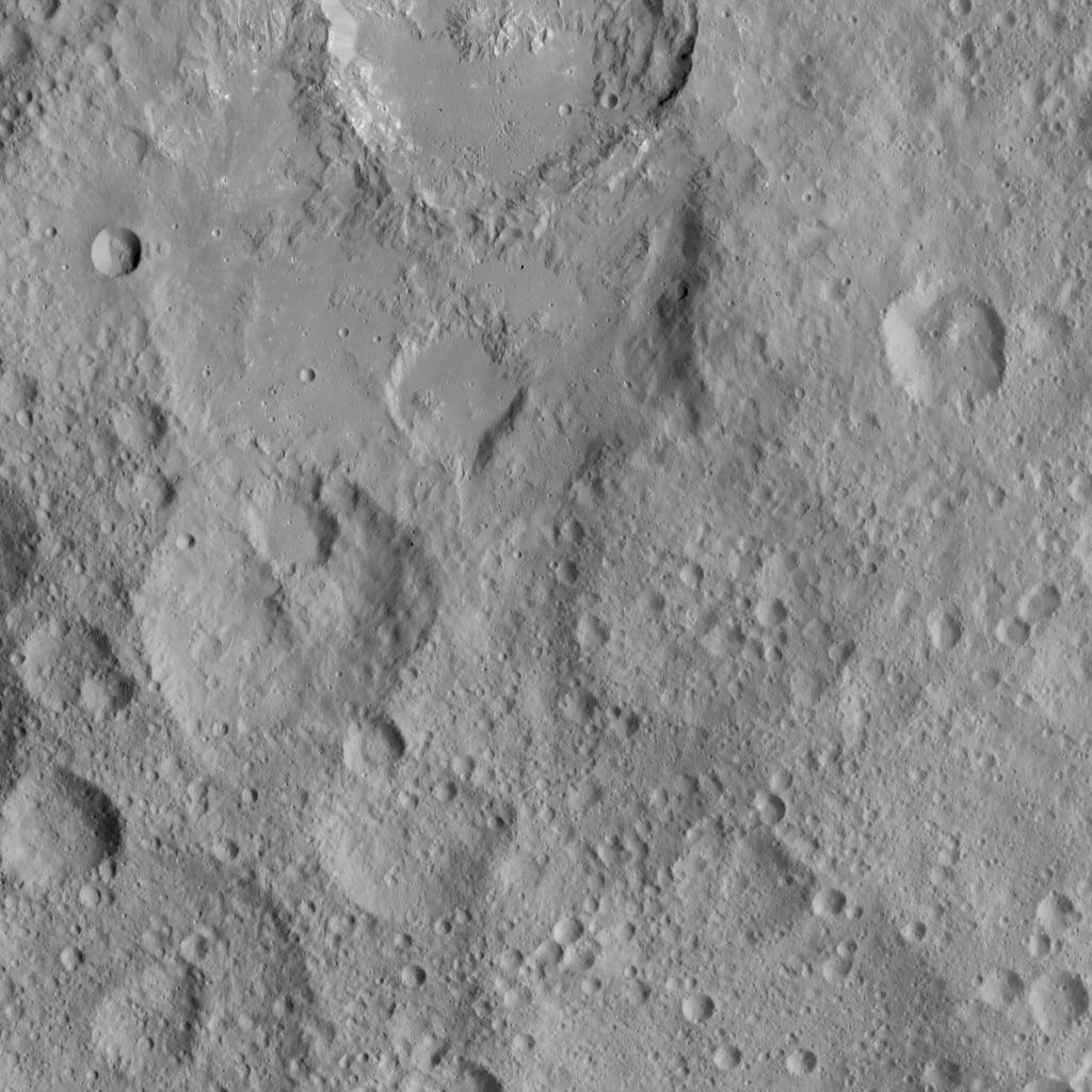
English: PIA20127: Dawn HAMO Image 64
http://photojournal.jpl.nasa.gov/catalog/PIA20127 This image shows cratered terrain in the northern hemisphere of Ceres. Ikapati crater (top) appears with several flat plains filled by flows, smooth material and ejecta from the crater interior. On the crater floor and on some of the planes there are clusters of small pits and pits surrounded by light material. Dawn took this image on Oct. 6, 2015, from an altitude of 915 miles (1,470 kilometers). It has a resolution of 450 feet (140 meters) per pixel. The image is located at 36 degrees north latitude, 43 degrees east longitude. Detailed maps of the polar regions allow researchers to study the craters in this area and compare them to those covering other parts of Ceres. Variations in shape and complexity can point to different surface compositions. In addition, the bottoms of some craters located close to the poles receive no sunlight throughout Ceres' orbit around the sun. Scientists want to investigate whether surface ice can be found there. Dawn's mission is managed by JPL for NASA's Science Mission Directorate in Washington. Dawn is a project of the directorate's Discovery Program, managed by NASA's Marshall Space Flight Center in Huntsville, Alabama. UCLA is responsible for overall Dawn mission science. Orbital ATK, Inc., in Dulles, Virginia, designed and built the spacecraft. The German Aerospace Center, the Max Planck Institute for Solar System Research, the Italian Space Agency and the Italian National Astrophysical Institute are international partners on the mission team. For a complete list of acknowledgments, see http://dawn.jpl.nasa.gov/mission. For more information about the Dawn mission, visit http://dawn.jpl.nasa.gov. |
| Date | |
| Source | http://photojournal.jpl.nasa.gov/jpeg/PIA20127.jpg |
| Author | NASA/JPL-Caltech/UCLA/MPS/DLR/IDA |
Licensing
| This file is in the public domain in the United States because it was solely created by NASA. NASA copyright policy states that "NASA material is not protected by copyright unless noted". (See Template:PD-USGov, NASA copyright policy page or JPL Image Use Policy.) | ||
 |
Warnings:
|
File history
Click on a date/time to view the file as it appeared at that time.
| Date/Time | Thumbnail | Dimensions | User | Comment | |
|---|---|---|---|---|---|
| current | 17:35, 23 November 2015 |
| 1,024 × 1,024 (150 KB) | Drbogdan | User created page with UploadWizard |
File usage
Global file usage
The following other wikis use this file:
- Usage on ro.wikipedia.org
- Usage on uk.wikipedia.org