
Size of this preview:
525 × 600 pixels. Other resolutions:
210 × 240 pixels |
420 × 480 pixels |
700 × 800 pixels.
Original file (700 × 800 pixels, file size: 156 KB, MIME type: image/png)
| This is a file from the
Wikimedia Commons. Information from its
description page there is shown below. Commons is a freely licensed media file repository. You can help. |
Summary
| Description |
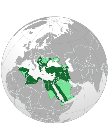
English: The borders of the Ottoman Empire in 1590 (before the long turkish war) |
| Date | |
| Source | Own work |
| Author | Siksok |

|
This map image could be re-created using
vector graphics as an
SVG file. This has several advantages; see
Commons:Media for cleanup for more information. If an SVG form of this image is available, please upload it and afterwards replace this template with
{{
vector version available|new image name}}
.
It is recommended to name the SVG file “Ottoman empire largest borders map.svg”—then the template Vector version available (or Vva) does not need the new image name parameter. |
Licensing
I, the copyright holder of this work, hereby publish it under the following license:
This file is licensed under the
Creative Commons
Attribution-Share Alike 3.0 Unported license.
- You are free:
- to share – to copy, distribute and transmit the work
- to remix – to adapt the work
- Under the following conditions:
- attribution – You must give appropriate credit, provide a link to the license, and indicate if changes were made. You may do so in any reasonable manner, but not in any way that suggests the licensor endorses you or your use.
- share alike – If you remix, transform, or build upon the material, you must distribute your contributions under the same or compatible license as the original.
File history
Click on a date/time to view the file as it appeared at that time.
| Date/Time | Thumbnail | Dimensions | User | Comment | |
|---|---|---|---|---|---|
| current | 17:51, 14 July 2023 |
| 700 × 800 (156 KB) | Bosphore9 | |
| 00:11, 9 January 2023 |
 | 700 × 800 (156 KB) | Bosphore9 | Les frontières les plus exactes | |
| 20:39, 16 September 2019 |
 | 679 × 679 (370 KB) | 𐰇𐱅𐰚𐰤 | improvements | |
| 12:58, 16 August 2014 |
 | 700 × 800 (330 KB) | AmbroiseL | Erreur de manipulation. | |
| 12:56, 16 August 2014 |
 | 700 × 800 (330 KB) | AmbroiseL | Reverted to version as of 12:54, 16 August 2014 | |
| 12:56, 16 August 2014 |
 | 700 × 800 (330 KB) | AmbroiseL | Frontières bien plus proches de la réalité que la version précédente ; de plus, les provinces vassales sont signalées par une couleur plus claire. | |
| 12:54, 16 August 2014 |
 | 700 × 800 (330 KB) | AmbroiseL | Frontières bien plus proches de la réalité que la version précédente qui incluait par exemple l'Ukraine entière, alors que celle-ci n’appartenait à l'Empire Ottoman que de part ses régions les plus méridionales ; de plus, les provinces vassa... | |
| 22:30, 21 May 2011 |
 | 700 × 800 (125 KB) | Siksok |
File usage
The following pages on the English Wikipedia use this file (pages on other projects are not listed):
Global file usage
The following other wikis use this file:
- Usage on ar.wikipedia.org
- Usage on hu.wikipedia.org
- Usage on id.wikipedia.org
- Usage on is.wikipedia.org
- Usage on ja.wikipedia.org
- Usage on mk.wikipedia.org
- Usage on ru.wikipedia.org
- Usage on sc.wikipedia.org
- Usage on sr.wiktionary.org