
Size of this preview:
461 × 600 pixels. Other resolutions:
184 × 240 pixels |
369 × 480 pixels |
590 × 768 pixels |
787 × 1,024 pixels |
1,537 × 2,000 pixels.
Original file (1,537 × 2,000 pixels, file size: 909 KB, MIME type: image/jpeg)
| This is a file from the
Wikimedia Commons. Information from its
description page there is shown below. Commons is a freely licensed media file repository. You can help. |
| Description |
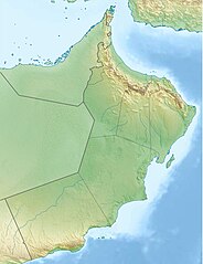
Deutsch: Physische Positionskarte von
Oman
Quadratische Plattkarte, N-S-Streckung 107 %. Geographische Begrenzung der Karte:
English: Physical location map of
Oman
Equirectangular projection, N/S stretching 107 %. Geographic limits of the map:
|
| Date | |
| Source |
Own work, using
|
| Author | Carport |
| Permission ( Reusing this file) |
This file is licensed under the
Creative Commons
Attribution-Share Alike 3.0 Unported license.
|
| Other versions |
|


File history
Click on a date/time to view the file as it appeared at that time.
| Date/Time | Thumbnail | Dimensions | User | Comment | |
|---|---|---|---|---|---|
| current | 20:17, 14 December 2012 |
| 1,537 × 2,000 (909 KB) | Carport | upd |
| 14:30, 12 December 2012 |
 | 1,537 × 2,000 (655 KB) | Carport | {{Information |Description= {{de|Physische Positionskarte von Oman}} Quadratische Plattkarte, N-S-Streckung 107 %. Geographische Begrenzung der Karte: * N: 26.6° N * S: 16.5° N * W: 51.8° O * O: 60.1° O {{en|Physical location map of [[... |
File usage
The following pages on the English Wikipedia use this file (pages on other projects are not listed):
- Al-Akhdhar, Oman
- Al-Buraimi
- Al Jalali Fort
- Al Qabil
- Al Saleel National Park
- Archaeological Sites of Bat, Al-Khutm and Al-Ayn
- Ash Sharqiyah North Governorate
- Ash Sharqiyah South Governorate
- Bahla Fort
- Bidiya
- Bilad Sayt
- Bukha
- Dhofar Mountains
- Dibba Al-Baya
- Gharif Formation
- Hajar Mountains
- Jabal Al Harim
- Jabal Samhan Nature Reserve
- Jebel Akhdar (Oman)
- Jebel Jais
- Jebel Qihwi
- Jebel Shams
- Khasab
- Khazzan-Makarem gas field
- Khor Rori
- Kumzar
- Land of Frankincense
- Madha
- Misfat al Abriyeen
- Mukhaizna Oil Field
- Muscat
- National Bank of Oman Golf Classic
- Nizwa
- Oman Open
- Qalhat
- Qurayyat, Oman
- Qurm Nature Reserve
- Rustaq
- Samail
- Sohar
- Sultan Qaboos Grand Mosque
- Sultan Qaboos Grand Mosque, Al-Buraimi
- Sultan Qaboos Grand Mosque, Sohar
- Sur, Oman
- Taqah
- Wadi Bani Khalid (Wilayat)
- Wadi Khabb Shamsi
- Wadi Tiwi
- Wakan, Oman
- Yibal
- User:Hike395/mountain bot diff
- Template:Infobox mountain/test versus status quo ante 3
- Module:Location map/data/Oman
- Module:Location map/data/Oman/doc
Global file usage
The following other wikis use this file:
- Usage on ast.wikipedia.org
- Usage on azb.wikipedia.org
- Usage on az.wikipedia.org
- Usage on bcl.wikipedia.org
- Usage on bg.wikipedia.org
- Usage on bn.wikipedia.org
- Usage on bs.wikipedia.org
- Usage on ceb.wikipedia.org
- Usage on ce.wikipedia.org
- Usage on da.wikipedia.org
- Usage on de.wikipedia.org
View more global usage of this file.