
Original file (704 × 800 pixels, file size: 47 KB, MIME type: image/png)
| This is a file from the
Wikimedia Commons. Information from its
description page there is shown below. Commons is a freely licensed media file repository. You can help. |
Summary
| Description |
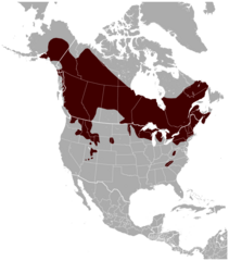
English: Geographical distribution of the Northern Flying Squirrel Glaucomys sabrinus. The map was created using the Generic Mapping Tools, GMT, version 5.1.1. |
| Date | |
| Source |
Own work using: the IUCN Red List spatial data to draw the borders of the Glaucomys sabrinus range: |
| Author | Darekk2 using the IUCN Red List spatial data |
Licensing
Attribution: The author of the work and the IUCN Red List spatial data.
You must provide the appropriate credit for the IUCN Red List spatial data:
IUCN (International Union for Conservation of Nature) 2008. Glaucomys sabrinus. In: IUCN 2014. The IUCN Red List of Threatened Species. Version 2014.3.
http://www.iucnredlist.org. Downloaded on 12 January 2015.
and the IUCN Red List spatial data
- You are free:
- to share – to copy, distribute and transmit the work
- to remix – to adapt the work
- Under the following conditions:
- attribution – You must give appropriate credit, provide a link to the license, and indicate if changes were made. You may do so in any reasonable manner, but not in any way that suggests the licensor endorses you or your use.
- share alike – If you remix, transform, or build upon the material, you must distribute your contributions under the same or compatible license as the original.
File history
Click on a date/time to view the file as it appeared at that time.
| Date/Time | Thumbnail | Dimensions | User | Comment | |
|---|---|---|---|---|---|
| current | 19:37, 9 July 2017 |
| 704 × 800 (47 KB) | NordNordWest | - new species ''Glaucomys oregonensis'' |
| 23:50, 26 May 2015 |
 | 704 × 800 (122 KB) | Darekk2 | Reverted to version as of 23:33, 26 May 2015 | |
| 23:33, 26 May 2015 |
 | 704 × 800 (122 KB) | Darekk2 | that was volans | |
| 17:18, 20 March 2015 |
 | 705 × 800 (118 KB) | Darekk2 | removed transparency of the background | |
| 10:11, 15 January 2015 |
 | 705 × 800 (125 KB) | Darekk2 | User created page with UploadWizard |
File usage
Global file usage
The following other wikis use this file:
- Usage on arz.wikipedia.org
- Usage on ast.wikipedia.org
- Usage on avk.wikipedia.org
- Usage on bg.wikipedia.org
- Usage on ca.wikipedia.org
- Usage on ceb.wikipedia.org
- Usage on cs.wikipedia.org
- Usage on de.wikipedia.org
- Usage on es.wikipedia.org
- Usage on eu.wikipedia.org
- Usage on fa.wikipedia.org
- Usage on fi.wikipedia.org
- Usage on fr.wikipedia.org
- Usage on fy.wikipedia.org
- Usage on he.wikipedia.org
- Usage on hu.wikipedia.org
- Usage on it.wikipedia.org
- Usage on ko.wikipedia.org
- Usage on nl.wikipedia.org
- Usage on nv.wikipedia.org
- Usage on pl.wikipedia.org
- Usage on ru.wikipedia.org
- Usage on sv.wikipedia.org
- Usage on uk.wikipedia.org
- Usage on vi.wikipedia.org
- Usage on www.wikidata.org
- Usage on zh.wikipedia.org