
Size of this preview:
662 × 600 pixels. Other resolutions:
265 × 240 pixels |
530 × 480 pixels |
848 × 768 pixels |
1,131 × 1,024 pixels |
2,261 × 2,048 pixels |
5,190 × 4,701 pixels.
Original file (5,190 × 4,701 pixels, file size: 9.09 MB, MIME type: image/jpeg)
| This is a file from the
Wikimedia Commons. Information from its
description page there is shown below. Commons is a freely licensed media file repository. You can help. |
Summary
| Description |
Bahasa Melayu:
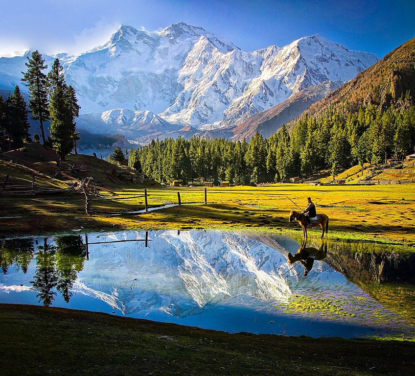
Nanga Prabat ialah gunung ke-9 tertinggi di dunia, dengan ketinggian 8,126 meter dari aras laut. Ia adalah penambat barat bagi pergunungan
Himalaya di sekitar di mana sungai Indus menyempadani ke dataran Pakistan. English: Nanga Parbat is the ninth highest mountain in the world at 8,126 metres above sea level. It is the western anchor of the Himalayas around which the Indus river skirts into the plains of Pakistan. |
| Date | |
| Source | Own work |
| Author | Tahsin Anwar Ali |
| Other versions |
.jpg)
Assessment
|
Licensing
I, the copyright holder of this work, hereby publish it under the following license:
This file is licensed under the
Creative Commons
Attribution-Share Alike 3.0 Unported license.
- You are free:
- to share – to copy, distribute and transmit the work
- to remix – to adapt the work
- Under the following conditions:
- attribution – You must give appropriate credit, provide a link to the license, and indicate if changes were made. You may do so in any reasonable manner, but not in any way that suggests the licensor endorses you or your use.
- share alike – If you remix, transform, or build upon the material, you must distribute your contributions under the same or compatible license as the original.
|
|
This image was uploaded as part of
Wiki Loves Earth 2015.
|
 |

|
This image won the 6th prize in the national contest of Pakistan in
Wiki Loves Earth 2015 Other languages:
|
File history
Click on a date/time to view the file as it appeared at that time.
| Date/Time | Thumbnail | Dimensions | User | Comment | |
|---|---|---|---|---|---|
| current | 20:11, 15 August 2017 |
| 5,190 × 4,701 (9.09 MB) | Willard84 | Brightened the |
| 09:00, 31 May 2015 |
 | 5,190 × 4,701 (18.09 MB) | Tahsin Anwar Ali | User created page with UploadWizard |
File usage
The following pages on the English Wikipedia use this file (pages on other projects are not listed):
Global file usage
The following other wikis use this file:
- Usage on ar.wikipedia.org
- Usage on az.wikipedia.org
- Usage on bh.wikipedia.org
- Usage on bn.wikipedia.org
- Usage on de.wikipedia.org
- Usage on en.wikivoyage.org
- Usage on es.wikipedia.org
- Usage on eu.wikipedia.org
- Usage on fa.wikipedia.org
- Usage on gl.wikipedia.org
- Usage on id.wikipedia.org
- Usage on it.wikipedia.org
- Usage on it.wikivoyage.org
- Usage on ja.wikipedia.org
- Usage on mk.wikipedia.org
- Usage on ms.wikipedia.org
- Usage on ne.wikipedia.org
- Usage on or.wikipedia.org
- Usage on pl.wikipedia.org
- Dyskusja wikipedysty:Polinik
- Dyskusja wikipedysty:Bloody Adam/Archiwum 3
- Dyskusja wikipedysty:Budd Le Toux
- Dyskusja wikipedysty:Gustaw1410
- Dyskusja wikipedysty:Halavar
- Dyskusja wikipedysty:Wiroid
- Dyskusja wikipedysty:Stupa1989
- Dyskusja wikipedysty:Panna Wodzianna
- Dyskusja wikipedysty:Dawid Brudniewicz
- Dyskusja wikipedysty:Tolixus
- Dyskusja wikipedysty:Stvari
- Dyskusja wikipedysty:Gregok
- Dyskusja wikipedysty:Sauron00000
- Dyskusja wikipedysty:Borowiecki.km
- Dyskusja wikipedysty:Bonvol/Archiwum do 2021
- Dyskusja wikipedysty:OlafMaj1
- Dyskusja wikipedysty:Luki4812
- Dyskusja wikipedystki:Bialke
- Dyskusja wikipedysty:Patounia
- Dyskusja wikipedysty:Sympathicc
View more global usage of this file.