Size of this preview:
800 × 436 pixels. Other resolutions:
320 × 175 pixels |
860 × 469 pixels.
Original file (860 × 469 pixels, file size: 201 KB, MIME type: image/jpeg)
| This is a file from the
Wikimedia Commons. Information from its
description page there is shown below. Commons is a freely licensed media file repository. You can help. |

|
This map image could be re-created using
vector graphics as an
SVG file. This has several advantages; see
Commons:Media for cleanup for more information. If an SVG form of this image is available, please upload it and afterwards replace this template with
{{
vector version available|new image name}}
.
It is recommended to name the SVG file “Mongolia 1500 AD.svg”—then the template Vector version available (or Vva) does not need the new image name parameter. |


Summary
| Description |
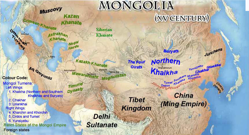
English: Mongolian domains and relict states of the Mongol Empire |
| Date | |
| Source | Own work |
| Author | Lady Anu |
Licensing
I, the copyright holder of this work, hereby publish it under the following licenses:

|
Permission is granted to copy, distribute and/or modify this document under the terms of the GNU Free Documentation License, Version 1.2 or any later version published by the Free Software Foundation; with no Invariant Sections, no Front-Cover Texts, and no Back-Cover Texts. A copy of the license is included in the section entitled GNU Free Documentation License. |
| This file is licensed under the Creative Commons Attribution-Share Alike 3.0 Unported license. | ||
| ||
| This licensing tag was added to this file as part of the GFDL licensing update. |
| Copyleft: This work of art is free; you can redistribute it and/or modify it according to terms of the Free Art License. You will find a specimen of this license on the Copyleft Attitude site as well as on other sites. |
You may select the license of your choice.
File history
Click on a date/time to view the file as it appeared at that time.
| Date/Time | Thumbnail | Dimensions | User | Comment | |
|---|---|---|---|---|---|
| current | 07:05, 30 July 2014 |
| 860 × 469 (201 KB) | Sven Manguard | As per Commons:Overwriting existing files |
| 06:59, 30 July 2014 |
 | 860 × 469 (255 KB) | Flamarial~commonswiki | Reverting evidence-lacking vandalism by User:Tm. | |
| 05:48, 30 July 2014 |
 | 860 × 469 (201 KB) | Tm | Reverted to version as of 21:19, 29 July 2014 reverting persistant vandalism | |
| 05:17, 30 July 2014 |
 | 860 × 469 (255 KB) | Flamarial~commonswiki | Reverting evidence-lacking vandalism by User:Tm. | |
| 21:19, 29 July 2014 |
 | 860 × 469 (201 KB) | Tm | Reverted to version as of 03:25, 15 January 2012 reverting vandalism | |
| 14:56, 29 July 2014 |
 | 860 × 469 (255 KB) | Flamarial~commonswiki | Previous version was historically inaccurate: Korea was not a part of the Mongol Empire. | |
| 03:25, 15 January 2012 |
 | 860 × 469 (201 KB) | Lady Anu | By the initial idea, this map roughly pertains to mid 15th century. It was my mistake to omit the Choson Dynasty that existed during that period. However, the main purpose of creating this map was to give a very basic understanding of the locations of the | |
| 02:49, 23 December 2010 |
 | 860 × 469 (100 KB) | Tm | Reverted to version as of 02:27, 19 December 2010: Please read : http://commons.wikimedia.org/?title=Commons:Village_pump&diff=33196237&oldid=33196194 and https://secure.wikimedia.org/wikipedia/commons/wiki/Commons:Village_pump#Edit_warring_ove | |
| 02:34, 23 December 2010 |
 | 860 × 469 (255 KB) | Historiographer~commonswiki | Once again, distinguished between Tributary and Annexation. Korea was different with China. | |
| 02:27, 19 December 2010 |
 | 860 × 469 (100 KB) | Tm | Reverted to version as of 00:39, 18 December 2010 |
File usage
The following pages on the English Wikipedia use this file (pages on other projects are not listed):
Global file usage
The following other wikis use this file:
- Usage on ar.wikipedia.org
- Usage on azb.wikipedia.org
- Usage on az.wikipedia.org
- Usage on ca.wikipedia.org
- Usage on cs.wikipedia.org
- Usage on de.wikipedia.org
- Usage on eu.wikipedia.org
- Usage on fr.wikipedia.org
- Usage on he.wikipedia.org
- Usage on hu.wikipedia.org
- Usage on hy.wikipedia.org
- Usage on it.wikipedia.org
- Usage on mn.wikipedia.org
- Usage on ms.wikipedia.org
- Usage on nl.wikipedia.org
- Usage on pnb.wikipedia.org
- Usage on pt.wikipedia.org
- Usage on ru.wikipedia.org
- Usage on sl.wikipedia.org
- Usage on sv.wikipedia.org
- Usage on ta.wikipedia.org
- Usage on ur.wikipedia.org
- Usage on uz.wikipedia.org
- Usage on xmf.wikipedia.org
- Usage on zh.wikipedia.org