
Size of this preview:
736 × 600 pixels. Other resolutions:
295 × 240 pixels |
589 × 480 pixels |
942 × 768 pixels |
1,256 × 1,024 pixels |
2,513 × 2,048 pixels |
2,650 × 2,160 pixels.
Original file (2,650 × 2,160 pixels, file size: 726 KB, MIME type: image/png)
| This is a file from the
Wikimedia Commons. Information from its
description page there is shown below. Commons is a freely licensed media file repository. You can help. |
Summary
| Description |
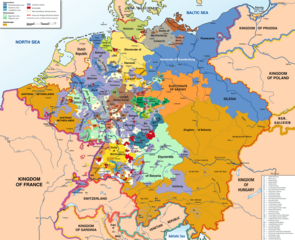
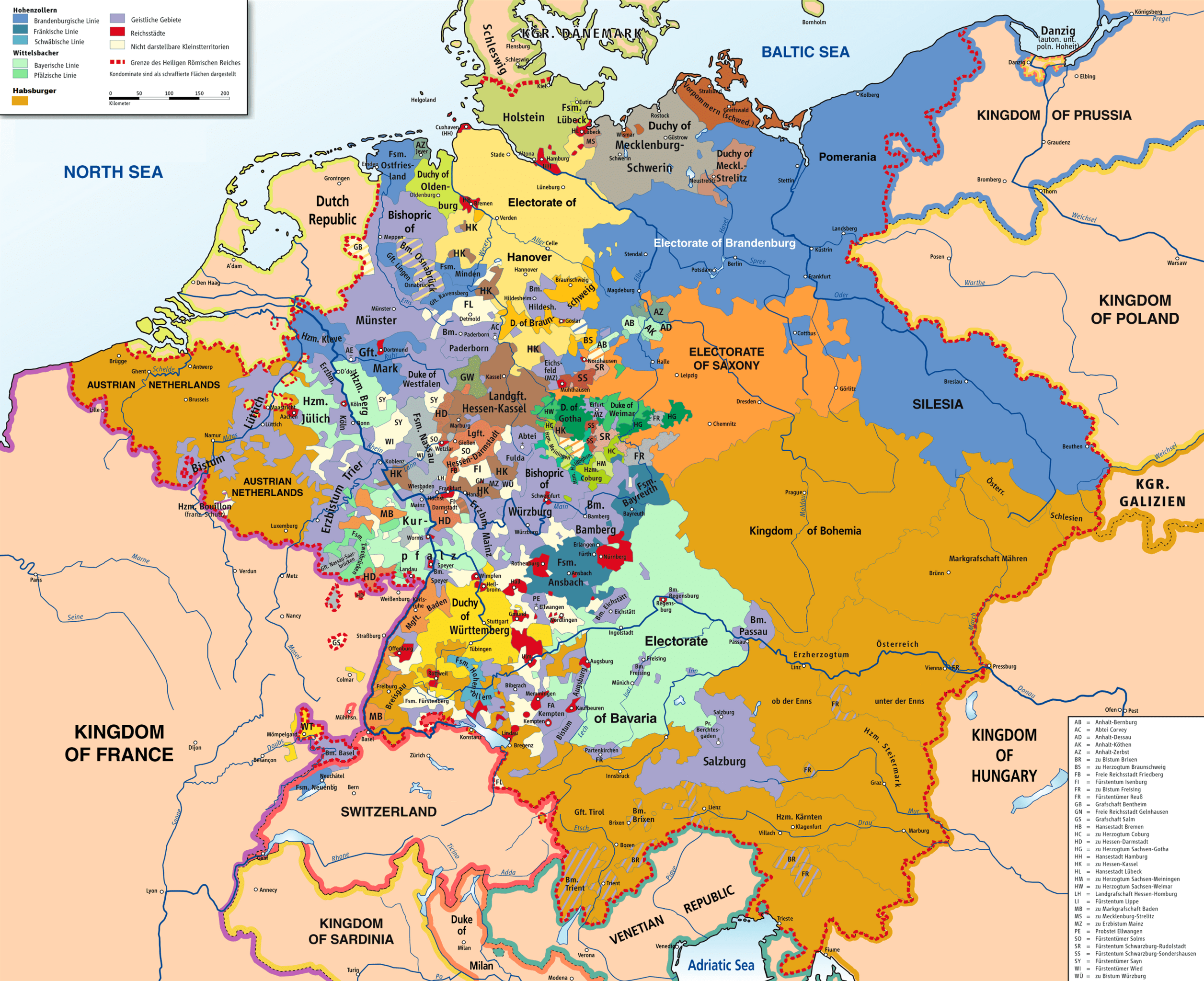
English: Map of the Holy Roman Empire, 1789. |
||
| Date | |||
| Source |
Own work based on: HRR 1789.png "translated (somewhat) from original German version" References:
|
||
| Creator |
Robert Alfers,
ziegelbrenner |
||
| Georeferencing | If inappropriate please set warp_status = skip to hide. | ||
| Other versions |
 Ursprungskarte in Deutsch
|

Licensing
This file is licensed under the
Creative Commons Attribution-Share Alike
3.0 Unported,
2.5 Generic,
2.0 Generic and
1.0 Generic license.
- You are free:
- to share – to copy, distribute and transmit the work
- to remix – to adapt the work
- Under the following conditions:
- attribution – You must give appropriate credit, provide a link to the license, and indicate if changes were made. You may do so in any reasonable manner, but not in any way that suggests the licensor endorses you or your use.
- share alike – If you remix, transform, or build upon the material, you must distribute your contributions under the same or compatible license as the original.
File history
Click on a date/time to view the file as it appeared at that time.
| Date/Time | Thumbnail | Dimensions | User | Comment | |
|---|---|---|---|---|---|
| current | 14:47, 30 November 2018 |
| 2,650 × 2,160 (726 KB) | FDRMRZUSA | Implemented map legend: inserted "Kilometers". |
| 22:59, 29 November 2018 |
 | 2,650 × 2,160 (810 KB) | FDRMRZUSA | Implemented map legend: "Habsburger". Reduced dimensions (size). | |
| 16:17, 17 February 2013 |
 | 2,650 × 2,160 (2.69 MB) | Opus33 | I've added a few more English place names, as follows: Wien > Vienna Muenchen > Munich Mailand > Milan Bruessel > Brussels Prag > Prague Antwerpen > Antwerp Triest > Trieste Warschau > Warsaw Gent > Ghent Erzbistum removed from Salzburg; should be Ar... | |
| 17:08, 2 July 2010 |
 | 2,650 × 2,160 (2.55 MB) | Ras67 | cropped | |
| 04:09, 8 June 2008 |
 | 2,659 × 2,170 (2.62 MB) | RobNS | {{Information |Description={{en|1=Map of the Holy Roman Empire, 1789, translated (somewhat) from original German version on Wikipedia Commons}} |Source=Own source, translated map from Image:HRR 1789.png, also on WC |Author=Robert Alfers, [[:de:Benutzer:kg |
File usage
The following pages on the English Wikipedia use this file (pages on other projects are not listed):
- Army of Sambre and Meuse
- Austria–Germany relations
- Battle of Kehl (1796)
- Battle of Rastatt (1796)
- Dissolution of the Holy Roman Empire
- Early clashes in the Rhine campaign of 1796
- German mediatisation
- Imperial immediacy
- Kleinstaaterei
- Names of Germany
- Nationality of Wolfgang Amadeus Mozart
- Rhine campaign of 1795
- Rhine campaign of 1796
- Siege of Hüningen (1796–1797)
- Siege of Kehl (1796–1797)
- Unification of Germany
- Talk:Holy Roman Empire/Archive 1
- User:Bunhouse768/sandbox
- User:Dainomite/sandbox
- User:Dronebogus/Don’t Balkanize Wikipedia
- User:Falcaorib/Germany and Prussia
- User:JMvanDijk/Sandbox 10
- Wikipedia:Graphics Lab/Map workshop/Archive/Dec 2012
- Wikipedia:Village pump (technical)/Archive 144
Global file usage
The following other wikis use this file:
- Usage on als.wikipedia.org
- Usage on ar.wikipedia.org
- Usage on azb.wikipedia.org
- Usage on az.wikipedia.org
- Usage on be.wikipedia.org
- Usage on bg.wikipedia.org
- Usage on ca.wikipedia.org
- Usage on cs.wikipedia.org
- Usage on da.wikipedia.org
- Usage on de.wikipedia.org
- Usage on el.wikipedia.org
- Usage on es.wikipedia.org
- Usage on et.wikipedia.org
- Usage on gl.wikipedia.org
- Usage on he.wikipedia.org
- Usage on hy.wikipedia.org
- Usage on id.wikipedia.org
- Usage on it.wikipedia.org
- Usage on ja.wikipedia.org
- Usage on ja.wikiversity.org
- Usage on ka.wikipedia.org
- Usage on ko.wikipedia.org
View more global usage of this file.