Photos • Location


Size of this preview:
791 × 600 pixels. Other resolutions:
317 × 240 pixels |
633 × 480 pixels |
1,013 × 768 pixels |
1,280 × 970 pixels |
1,835 × 1,391 pixels.
Original file (1,835 × 1,391 pixels, file size: 232 KB, MIME type: image/jpeg)
| This is a file from the
Wikimedia Commons. Information from its
description page there is shown below. Commons is a freely licensed media file repository. You can help. |
_Islets_E-7218.jpg)
Summary
| Description |
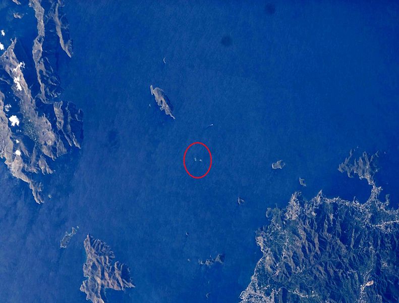
English: Location of the Imia islets in the Aegean Sea. Türkçe: Kardak (Imia) Adalarının Ege Denizindeki konumu. Ελληνικά: Τοποθεσία των νησιών Ιμίων (Kardak) στο Αιγαίο Πέλαγος. Français : Lieu de Kardak (Imia) îles de la mer Egée. Deutsch: Lage Kardak (Imia) Inseln in der Ägäis. Español: Lugar de Kardak (IMIA) las islas del mar Egeo. Português: Localização do Kardak (Imia) ilhas do Mar Egeu. Italiano: Posizione Kardak (Imia) isole del Mar Egeo. Nederlands: Locatie van Kardak (Imia) eilanden in de Egeïsche Zee. Dansk: Placering af Kardak (Imia) øer i Det Ægæiske Hav. Suomi: Sijainti Kardak (Imia) saarille Egeanmeren. Svenska: Placering av Kardak (Imia) öar i Egeiska havet. Polski: Lokalizacja Kardak (Imia) wysp na Morzu Egejskim. Norsk nynorsk: Plassering av Kardak (Imia) øyene i Egeerhavet. Azərbaycanca: Ege dənizində Kardak (Imia) adalar mövqe. Afrikaans: Ligging van Kardak (Imia) eilande in die Egeïese See. Română: Locul de amplasare a Kardak (Imia) insulele din Marea Egee. Čeština: Poloha ostrovů Kardak (IMIA) v Egejském moři. Русский: Расположение Kardak (IMIA) островов в Эгейском море. 中文(中国大陆):Kardak(IMIA)在爱琴海的岛屿的位置。 日本語: エーゲ海のKardak(IMIA)島の場所。 한국어: 에게 해 에게 해의 Kardak (Imia) 섬의 위치. العربية: موقع الجزر (إيميا) كارداك في بحر إيجة. עברית: מיקום של איי Kardak (Imia) בים האגאי. |
| Date | |
| Source | http://eol.jsc.nasa.gov/scripts/sseop/QuickView.pl?directory=ESC&ID=ISS022-E-7218 |
| Author | NASA |
| Permission ( Reusing this file) |
Conditions of Use of Astronaut Photographs |
| Camera location |
| View this and other nearby images on: OpenStreetMap |
|
|---|
_Islets_E-7218.jpg¶ms=037.050833_N_0027.151111_E_globe:Earth_type:camera__&language=en)
Licensing
This image or video was catalogued by Johnson Space Center of the United States
National Aeronautics and Space Administration (NASA) under Photo ID:
ISS022-E-7218. This tag does not indicate the copyright status of the attached work. A normal copyright tag is still required. See Commons:Licensing. Other languages:
|
| This is a
retouched picture, which means that it has been digitally altered from its original version. Modifications: cropped,marked,color adjusted and rotated (180°). Modifications made by
Maurice07.
|
This file is in the
public domain in the United States because it was created by the Image Science & Analysis Laboratory, of the
NASA Johnson Space Center. NASA copyright policy states that "NASA material is not protected by copyright unless noted". (
NASA media use guidelines or
Conditions of Use of Astronaut Photographs).
Photo source:
ISS022-E-7218.
|
File history
Click on a date/time to view the file as it appeared at that time.
| Date/Time | Thumbnail | Dimensions | User | Comment | |
|---|---|---|---|---|---|
| current | 02:04, 25 December 2012 |
| 1,835 × 1,391 (232 KB) | Maurice07 | User created page with UploadWizard |
File usage
The following pages on the English Wikipedia use this file (pages on other projects are not listed):
Global file usage
The following other wikis use this file:
- Usage on ar.wikipedia.org
- Usage on ca.wikipedia.org
- Usage on ceb.wikipedia.org
- Usage on el.wikipedia.org
- Usage on es.wikipedia.org
- Usage on eu.wikipedia.org
- Usage on fi.wikipedia.org
- Usage on fr.wikipedia.org
- Usage on gl.wikipedia.org
- Usage on id.wikipedia.org
- Usage on it.wikipedia.org
- Usage on ko.wikipedia.org
- Usage on no.wikipedia.org
- Usage on pl.wikipedia.org
- Usage on ru.wikipedia.org
- Usage on sv.wikipedia.org
- Usage on tr.wikipedia.org
- Usage on www.wikidata.org
_Islets_E-7218.jpg)