
Size of this preview:
776 × 600 pixels. Other resolutions:
311 × 240 pixels |
621 × 480 pixels |
994 × 768 pixels |
1,280 × 990 pixels |
2,560 × 1,979 pixels |
5,016 × 3,878 pixels.
Original file (5,016 × 3,878 pixels, file size: 13.06 MB, MIME type: image/jpeg)
| This is a file from the
Wikimedia Commons. Information from its
description page there is shown below. Commons is a freely licensed media file repository. You can help. |
|
| This is a featured picture, which means that members of the community have identified it as one of the finest images on the English Wikipedia, adding significantly to its accompanying article. If you have a different image of similar quality, be sure to upload it using the proper free license tag, add it to a relevant article, and nominate it. |
|
| This image was selected as picture of the day on the English Wikipedia for June 10, 2011. |
Summary
_en.png)
.png)
.jpg)
Licensing
|
This work is in the public domain in its country of origin and other countries and areas where the copyright term is the author's life plus 100 years or fewer. | |
| This file has been identified as being free of known restrictions under copyright law, including all related and neighboring rights. | |
Assessment
|
This image was selected as
picture of the day on Wikimedia Commons for
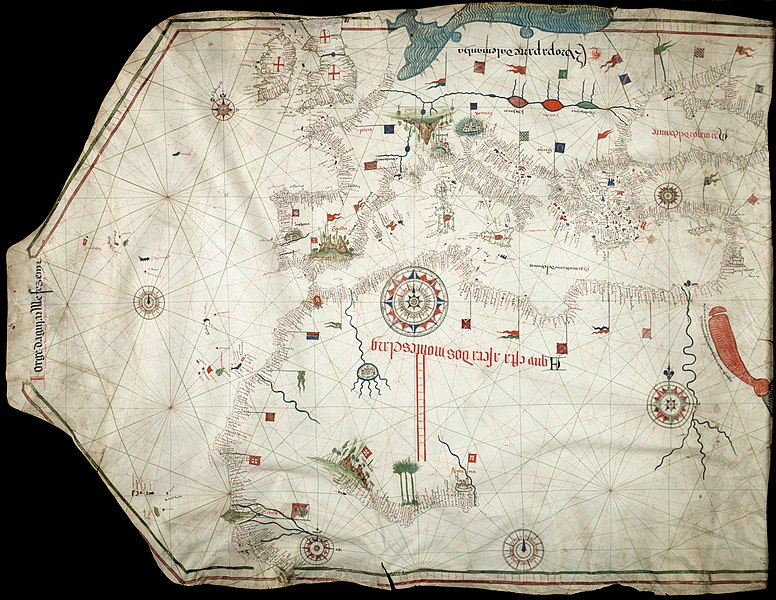
10 June 2011. It was captioned as follows: English: Reproduction of Jorge de Aguiar's chart of the
Mediterranean,
Western Europe and
African Coast (1492). Size of the original: 1030×770 mm Other languages:
Deutsch: Reproduktion von Jorge de Aguiars Karte des
Mittelmeerraumes, der
westeuropäischen und
afrikanischen Küste aus dem Jahr 1492 – Größe des Originales: 1.030 mm × 770 mm English: Reproduction of Jorge de Aguiar's chart of the
Mediterranean,
Western Europe and
African Coast (1492). Size of the original: 1030×770 mm Español: Reproducción del mapa de Jorge de Aguiar de la
cuenca mediterránea,
Europa Occidental y la costa
africana (1492). Tamaño del original: 1030×770 mm. Esperanto: Reproduktaĵo de mapo pri la mediteraneaj, okcidenteŭropaj kaj afrikaj marbordoj, farita de la kartografo Jorge de Aguiar en 1492. Mezuroj de la originalo: 1030×770 mm. Français : Reproduction de la carte des côtes méditerranéenne, d'
Europe et d'
Afrique de l'Ouest par Jorge de Aguiar (1492). Italiano: Riproduzione della carta di Jorge de Aguiar delle coste del
Mediterraneo, dell'
Europa occidentale e dell'
Africa settenrionale (1492). Dimensioni dell'originale: 1030×770 mm Magyar: Jorge de Aguiar térképének másolata: a Mediterrán térség, Nyugat-Európa, és az Afrikai part (1492). Méret: 1030×770 mm Nederlands: Een reproductie van de kaart van de hand van Jorge de Aguiar van de
Middellandse Zee,
West-Europa en de
Afrikaanse kust (1492). Het origineel is 1030×770 mm. Русский: Репродукция карты
Средиземного Моря,
Европы и африканского побережья, составленной Хорхе де Агияром (1492). Українська: Відтворення карти
Середземномор'я,
Західної Європи і
африканського узбережжя
португальського картографа Хорхе де Агілара (Jorge de Aguiar) (1492). Розмір оригіналу: 1030×770 мм. Із зібрань Бібліотеки Бейнеке рідких книг і рукописів (Beinecke Rare Book & Manuscript Library)
Єльського університету 日本語: ジョルジュ・デ・アギアルによる地中海、西ヨーロッパ及びアフリカ沿岸の
海図(1492年)の複製。原画の寸法1030ミリメートル×770ミリメートル。 中文: 乔治·德阿吉亚尔绘制的地中海、西欧和非洲海岸图(1492年)复制品。原始尺寸:1030×770mm。 |
File history
Click on a date/time to view the file as it appeared at that time.
| Date/Time | Thumbnail | Dimensions | User | Comment | |
|---|---|---|---|---|---|
| current | 12:32, 24 November 2010 |
| 5,016 × 3,878 (13.06 MB) | Alvesgaspar | {{Information |Description={{en|1=Reproduction of Jorge de Aguiar's chart of the Mediterranean, Western Europe and African Coast (1492). Size of the origial: 1030 x 770 mm}} |Source=Beinecke Rare Book and Manuscript Library, University of Yale, New Have, |
File usage
The following pages on the English Wikipedia use this file (pages on other projects are not listed):
- Iberian cartography, 1400–1600
- Portolan chart
- Talk:Iberian cartography, 1400–1600
- User:Alvesgaspar
- User:Falcaorib/Europe
- User:Walrasiad/Maps
- User talk:Alvesgaspar/archive2
- Wikipedia:Featured picture candidates/December-2010
- Wikipedia:Featured picture candidates/File:Jorge Aguiar 1492 MR.jpg
- Wikipedia:Featured pictures/Diagrams, drawings, and maps/Maps
- Wikipedia:Featured pictures thumbs/26
- Wikipedia:Main Page history/2011 June 10
- Wikipedia:Picture of the day/June 2011
- Wikipedia:Wikipedia Signpost/2010-12-27/Features and admins
- Wikipedia:Wikipedia Signpost/Single/2010-12-27
- Template:POTD/2011-06-10
- Portal:Geography/Selected picture
Global file usage
The following other wikis use this file:
- Usage on ar.wikipedia.org
- Usage on ba.wikipedia.org
- Usage on be-tarask.wikipedia.org
- Usage on bn.wikipedia.org
- Usage on ca.wikipedia.org
- Usage on crh.wikipedia.org
- Usage on cv.wikipedia.org
- Usage on es.wikipedia.org
- Usage on fa.wikipedia.org
- Usage on fr.wikipedia.org
- Usage on hu.wikipedia.org
- Usage on it.wikipedia.org
- Usage on kk.wikipedia.org
- Usage on ko.wikipedia.org
- Usage on lbe.wikipedia.org
- Usage on oc.wikipedia.org
- Usage on os.wikipedia.org
- Usage on pl.wikipedia.org
- Usage on pt.wikipedia.org
- Usage on ro.wikipedia.org
- Usage on ru.wikipedia.org
- Usage on ru.wikinews.org
- Usage on sah.wikipedia.org
- Usage on sl.wikipedia.org
- Usage on sv.wikipedia.org
- Usage on uk.wikipedia.org
- Usage on vi.wikipedia.org
- Usage on xal.wikipedia.org
- Usage on zh.wikipedia.org