No higher resolution available.
ImperioOtomano1683.png (749 × 600 pixels, file size: 97 KB, MIME type: image/png)
| This is a file from the
Wikimedia Commons. Information from its
description page there is shown below. Commons is a freely licensed media file repository. You can help. |

|
This map image could be re-created using
vector graphics as an
SVG file. This has several advantages; see
Commons:Media for cleanup for more information. If an SVG form of this image is available, please upload it and afterwards replace this template with
{{
vector version available|new image name}}
.
It is recommended to name the SVG file “ImperioOtomano1683.svg”—then the template Vector version available (or Vva) does not need the new image name parameter. |
Summary
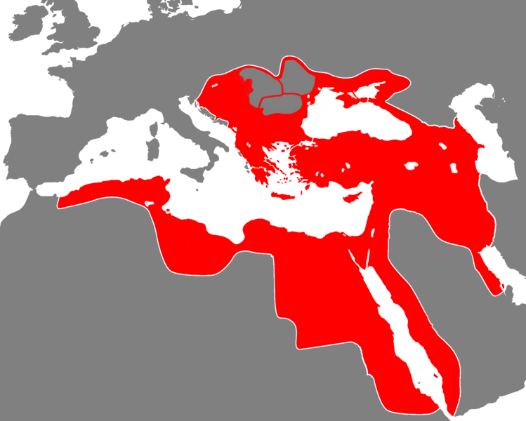
| Description | The Ottoman Empire during the 17th century |
| Date | 5/7/2007 |
| Source | |
| Author | viejoverde |

Licensing
| This work has been released into the
public domain by its author, I,
Viejoverde. This applies worldwide. In some countries this may not be legally possible; if so: I, Viejoverde grants anyone the right to use this work for any purpose, without any conditions, unless such conditions are required by law. |
File history
Click on a date/time to view the file as it appeared at that time.
| Date/Time | Thumbnail | Dimensions | User | Comment | |
|---|---|---|---|---|---|
| current | 13:09, 1 July 2014 |
| 749 × 600 (97 KB) | MetrouFan | Reverted to version as of 21:57, 1 October 2013 This version is more accurate. |
| 21:30, 5 October 2013 |
 | 1,684 × 1,348 (118 KB) | Underlying lk | this image is used on several articles, upload your image under a different name. | |
| 21:57, 1 October 2013 |
 | 749 × 600 (97 KB) | Spiridon Ion Cepleanu | Corrected since H.E. Stier (dir.) Grosser Atlas zur Weltgeschichte, Westermann 1985, ISBN 3-14-10-0919-8, pp. 71-119 and other atlases : christian principalities - vassals but not provinces of the Ottoman Sultanate : in grey marked out with red ; Ethio... | |
| 18:37, 10 March 2010 |
 | 1,684 × 1,348 (118 KB) | Rülpsmann | fixed Pelopponese | |
| 19:11, 9 March 2010 |
 | 1,684 × 1,348 (118 KB) | Rülpsmann | fixed colours (of the islands) | |
| 21:12, 24 January 2010 |
 | 1,684 × 1,348 (118 KB) | Rülpsmann | Reverted to version as of 13:38, 24 January 2010: This was 1683! Read a history book or look at the other images about Turkey! | |
| 18:34, 24 January 2010 |
 | 749 × 600 (88 KB) | Persia2099 | Reverted to version as of 23:30, 23 January 2010 | |
| 13:38, 24 January 2010 |
 | 1,684 × 1,348 (118 KB) | AteshCommons | Reverted to version as of 15:47, 11 December 2009 | |
| 23:30, 23 January 2010 |
 | 749 × 600 (88 KB) | Persia2099 | crrect(eastern borders) | |
| 15:47, 11 December 2009 |
 | 1,684 × 1,348 (118 KB) | Rülpsmann | corrected (East africa, azerbaijan) |
File usage
The following pages on the English Wikipedia use this file (pages on other projects are not listed):
Global file usage
The following other wikis use this file:
- Usage on af.wikipedia.org
- Usage on ar.wikipedia.org
- قائمة الخلفاء
- محمد الرابع (عثماني)
- الممالك في إفريقيا قبل الاستعمار
- بوابة:الإسلام/دولة مختارة
- بوابة:الإسلام/دولة مختارة/4
- مستخدم:باحث
- بوابة:التاريخ الإسلامي/دولة مختارة/أرشيف
- بوابة:التاريخ الإسلامي/دولة مختارة/1
- بوابة:العالم الإسلامي
- قالب:مواضيع متعلقة 3
- قالب:مواضيع متعلقة 3/شرح
- بوابة:العالم الإسلامي/تاريخ
- بوابة:العالم الإسلامي/مواضيع متعلقة
- شجرة العائلة العثمانية
- Usage on bn.wikipedia.org
- Usage on ca.wikipedia.org
- Usage on da.wikipedia.org
- Usage on de.wikipedia.org
- Usage on es.wikipedia.org
- Usage on fr.wikipedia.org
- Usage on fr.wiktionary.org
- Usage on hr.wikipedia.org
- Usage on hy.wikipedia.org
- Usage on id.wikipedia.org
- Usage on it.wikipedia.org
- Usage on ja.wikipedia.org
- Usage on ja.wiktionary.org
- Usage on pl.wikipedia.org
- Usage on pl.wiktionary.org
- Usage on pt.wikipedia.org
- Usage on ro.wikipedia.org
- Usage on sh.wikipedia.org
- Usage on tr.wikipedia.org
- Usage on zh.wikipedia.org