
Size of this preview:
800 × 450 pixels. Other resolutions:
320 × 180 pixels |
640 × 360 pixels |
1,024 × 576 pixels |
1,280 × 720 pixels |
2,560 × 1,440 pixels |
5,568 × 3,132 pixels.
Original file (5,568 × 3,132 pixels, file size: 8.84 MB, MIME type: image/jpeg)
| This is a file from the
Wikimedia Commons. Information from its
description page there is shown below. Commons is a freely licensed media file repository. You can help. |
Summary
| Description |
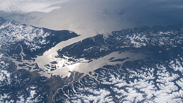
English: The Strait of Juan de Fuca and the Salish Sea, pictured from the International Space Station, separate the western-most border of the United States and Canada. |
| Date | Taken on 11 April 2020 |
| Source | https://www.flickr.com/photos/nasa2explore/49774289882/ |
| Author | NASA |
| Other versions |
|

.jpg)
This image or video was catalogued by Johnson Space Center of the United States
National Aeronautics and Space Administration (NASA) under Photo ID:
ISS062-E-147381. This tag does not indicate the copyright status of the attached work. A normal copyright tag is still required. See Commons:Licensing. Other languages:
|
Licensing
| This image, originally posted to Flickr, is currently not available on Flickr under the license specified on this page. However, please see {{PD-USGov-NASA-AP}} for permission to use it under this license. |
This file is in the
public domain in the United States because it was created by the Image Science & Analysis Laboratory, of the
NASA Johnson Space Center. NASA copyright policy states that "NASA material is not protected by copyright unless noted". (
NASA media use guidelines or
Conditions of Use of Astronaut Photographs).
Photo source:
ISS062-E-147381.
|
File history
Click on a date/time to view the file as it appeared at that time.
| Date/Time | Thumbnail | Dimensions | User | Comment | |
|---|---|---|---|---|---|
| current | 10:23, 9 October 2020 |
| 5,568 × 3,132 (8.84 MB) | Ponderosapine210 | Uploaded a work by NASA from https://www.flickr.com/photos/nasa2explore/49774289882/ with UploadWizard |
File usage
The following pages on the English Wikipedia use this file (pages on other projects are not listed):
Global file usage
The following other wikis use this file:
- Usage on he.wikipedia.org
- Usage on hy.wikipedia.org
- Usage on nn.wikipedia.org
- Usage on zh.wikipedia.org
.jpg)