Photos • Location


Size of this JPG preview of this TIF file:
800 × 515 pixels. Other resolutions:
320 × 206 pixels |
640 × 412 pixels |
1,024 × 659 pixels |
1,280 × 824 pixels |
2,560 × 1,647 pixels |
4,395 × 2,828 pixels.
Original file (4,395 × 2,828 pixels, file size: 11.85 MB, MIME type: image/tiff)
| This is a file from the
Wikimedia Commons. Information from its
description page there is shown below. Commons is a freely licensed media file repository. You can help. |
Summary
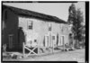
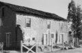
| Historic American Buildings Survey Roger Sturtevant, Photographer Jan. 27, 1934 WEST ELEVATION (REAR) - Caledonia Inn, Highway 101, San Miguel, San Luis Obispo County, CA | ||||
|---|---|---|---|---|
| Title |
Historic American Buildings Survey Roger Sturtevant, Photographer Jan. 27, 1934 WEST ELEVATION (REAR) - Caledonia Inn, Highway 101, San Miguel, San Luis Obispo County, CA |
|||
| Depicted place | California; San Luis Obispo County; San Miguel | |||
| Dimensions | 5 x 7 in. | |||
| Current location |
Library of Congress Prints and Photographs Division Washington, D.C. 20540 USA
http://hdl.loc.gov/loc.pnp/pp.print |
|||
| Accession number |
HABS CAL,40-SANMI.V,2-1 |
|||
| Credit line |
|
|||
| Source | https://www.loc.gov/pictures/item/ca0802.photos.017320p | |||
| Permission ( Reusing this file) |
|
|||
| Other versions | ||||

| Camera location |
| View this and other nearby images on: OpenStreetMap |
|
|---|
File history
Click on a date/time to view the file as it appeared at that time.
| Date/Time | Thumbnail | Dimensions | User | Comment | |
|---|---|---|---|---|---|
| current | 18:22, 22 September 2021 |
 | 4,395 × 2,828 (11.85 MB) | Cristiano Tomás | File:Historic American Buildings Survey Roger Sturtevant, Photographer Jan. 27, 1934 WEST ELEVATION (REAR) - Caledonia Inn, Highway 101, San Miguel, San Luis Obispo County, CA HABS CAL,40-SANMI.V,2-1.tif cropped 12 % horizontally, 20 % vertically using CropTool with precise mode. |
File usage
The following pages on the English Wikipedia use this file (pages on other projects are not listed):