No higher resolution available.
Heard_Island_and_McDonald_Islands-CIA_WFB_Map.png (365 × 392 pixels, file size: 4 KB, MIME type: image/png)
| This is a file from the
Wikimedia Commons. Information from its
description page there is shown below. Commons is a freely licensed media file repository. You can help. |
Summary
| Description |
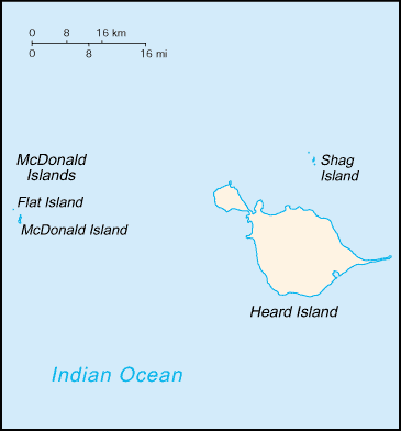
English: A map of the Territory of Heard Island and McDonald Islands, showing major islands. |
|||
| Date | published 2004 | |||
| Source | CIA, The World Factbook, 2004. | |||
| Author | CIA | |||
| Permission ( Reusing this file) |
|

File history
Click on a date/time to view the file as it appeared at that time.
| Date/Time | Thumbnail | Dimensions | User | Comment | |
|---|---|---|---|---|---|
| current | 09:14, 27 March 2005 |
| 365 × 392 (4 KB) | Wolfman~commonswiki | {{CIA-map}} |
File usage
The following pages on the English Wikipedia use this file (pages on other projects are not listed):
Global file usage
The following other wikis use this file:
- Usage on af.wikipedia.org
- Usage on az.wikipedia.org
- Usage on ckb.wikipedia.org
- Usage on fa.wikipedia.org
- Usage on fy.wikipedia.org
- Usage on gl.wikipedia.org
- Usage on he.wikipedia.org
- Usage on hi.wikipedia.org
- Usage on hu.wikipedia.org
- Usage on it.wikipedia.org
- Usage on ka.wikipedia.org
- Usage on ko.wikipedia.org
- Usage on nl.wikipedia.org
- Usage on nn.wikipedia.org
- Usage on pl.wikipedia.org
- Usage on pt.wikipedia.org
- Usage on rw.wikipedia.org
- Usage on yo.wikipedia.org
- Usage on zh.wikipedia.org