
Size of this PNG preview of this SVG file:
520 × 398 pixels. Other resolutions:
314 × 240 pixels |
627 × 480 pixels |
1,004 × 768 pixels |
1,280 × 980 pixels |
2,560 × 1,959 pixels.
Original file (SVG file, nominally 520 × 398 pixels, file size: 309 KB)
| This is a file from the
Wikimedia Commons. Information from its
description page there is shown below. Commons is a freely licensed media file repository. You can help. |
| Description |
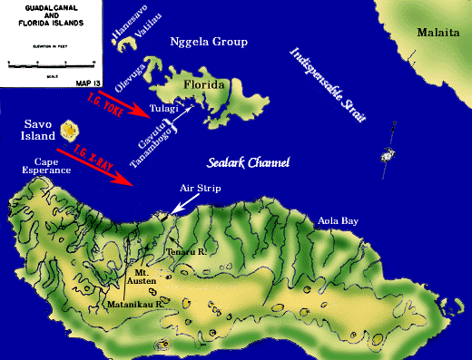
Route of Allied landing forces to Tulagi and Guadalcanal islands, August 7, 1942. Original from this website. This W3C-unspecified
vector image was created with
Inkscape . |
| Date | (UTC) |
| Source | |
| Author |
|
| This is a
retouched picture, which means that it has been digitally altered from its original version. Modifications: Converted to SVG. The original can be viewed here:
GuadTulagiLanding.gif:
|
| I, the copyright holder of this work, release this work into the
public domain. This applies worldwide. In some countries this may not be legally possible; if so: I grant anyone the right to use this work for any purpose, without any conditions, unless such conditions are required by law. |
Original upload log
This image is a derivative work of the following images:
-
File:GuadTulagiLanding.gif licensed with PD-USGov
- 2006-07-13T20:27:22Z Cla68 520x397 (68475 Bytes) Route of Allied landing forces to Tulagi and Guadalcanal islands, August 7, 1942. http://www.ibiblio.org/hyperwar/USMC/I/USMC-I-VI-1.html
Uploaded with derivativeFX
File history
Click on a date/time to view the file as it appeared at that time.
| Date/Time | Thumbnail | Dimensions | User | Comment | |
|---|---|---|---|---|---|
| current | 16:59, 19 March 2009 |
| 520 × 398 (309 KB) | TastyCakes | Last version was messed up |
| 16:57, 19 March 2009 |
 | 520 × 398 (325 KB) | TastyCakes | added rivers | |
| 18:05, 18 March 2009 |
 | 520 × 398 (293 KB) | TastyCakes | added Gavutu and Tanambogo, still needs rivers | |
| 17:42, 18 March 2009 |
 | 520 × 398 (291 KB) | TastyCakes | Tried to fix rendering problem | |
| 17:39, 18 March 2009 |
 | 520 × 398 (274 KB) | TastyCakes | {{Information |Description=Route of Allied landing forces to Tulagi and Guadalcanal islands, August 7, 1942. * |Source=* File:GuadTulagiLanding.gif |Date=2009-03-18 17:38 (UTC) |Author=* File:GuadTulagiLanding.gif: US Government *derivative work |
File usage
The following pages on the English Wikipedia use this file (pages on other projects are not listed):
Global file usage
The following other wikis use this file:
- Usage on azb.wikipedia.org
- Usage on bg.wikipedia.org
- Usage on br.wikipedia.org
- Usage on da.wikipedia.org
- Usage on fi.wikipedia.org
- Usage on id.wikipedia.org
- Usage on it.wikipedia.org
- Usage on ko.wikipedia.org
- Usage on no.wikipedia.org
- Usage on pt.wikipedia.org
- Usage on ru.wikipedia.org
- Usage on simple.wikipedia.org
- Usage on sv.wikipedia.org
- Usage on uk.wikipedia.org
- Usage on vi.wikipedia.org
- Usage on zh.wikipedia.org