
Size of this preview:
800 × 600 pixels. Other resolutions:
320 × 240 pixels |
640 × 480 pixels |
1,024 × 768 pixels |
1,280 × 960 pixels |
1,884 × 1,413 pixels.
Original file (1,884 × 1,413 pixels, file size: 421 KB, MIME type: image/jpeg)
| This is a file from the
Wikimedia Commons. Information from its
description page there is shown below. Commons is a freely licensed media file repository. You can help. |
Summary
| Description |
Deutsch:
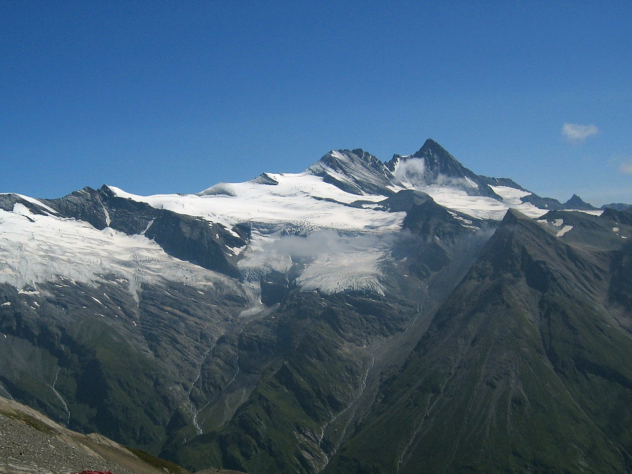
Großglockner vom Südwesten. Der Großglockner (3.797 m) ist der höchste pyramidenförmig erscheinende Gipfel rechts von der Mitte. Der breite großteils schneefreie Berg links davon ist die Glocknerwand (3.722 m) und ihr linker Eckpfeiler Hofmannspitze. Links im Bild ist über einer Felswand (Romariswand) der Romariswandkopf (3.511 m) zu sehen. Der pyramidenförmige Berg im Vordergrund, vor dem Großglockner, ist die Zollspitze (3.024 m).
Der Gletscher vor dem Großglockner ist das Teischnitzkees; rechts oberhalb der Romariswand ist das Fruschnitzkees. Aufnahmeort: Am Silesia Höhenweg, nahe dem Sattel nördlich des Gradötzkogel aufgenommen, in ca. 2.800 m Höhe und in 8 km Entfernung vom Gipfel des Großglockners.English: Großglockner seen from the southwest. The
Großglockner (3.797 m), the highest peak of
Austria, is the highest peak in the image, pyramid-shaped, right of the center. Left of it, the more elongated and mostly snow-free mountain is the Glocknerwand (3.722 m) with its left pillar Hofmannspitze. The Romariswandkopf (3.511 m) is the peak of the rock wall (Romariswand) in the left part of the image. The pyramid-shaped peak in front of the Großglockner is the Zollspitze (3.024 m). The glacier in front of the Großglockner is the Teischnitzkees, that behind and right of the Romariswand is the Fruschnitzkees. Français : Le Grossglockner vu du sud-ouest. Le
Grossglockner (3797 m), est le plus haut sommet d'Autriche. La montage plus allongée et presque libre de neige à sa gauche porte le Glocknerwand (3722 m) et le Hofmannspitze. Tout à gauche, le Romariswandkopf ("Pic du mur de pierre", 3511 m) est visible. Le sommet en forme de pyramide devant le Grossglockner s'appelle Zollspitze (3024 m). Le glacier visible devant le Grossglockner est le Teischnitzkees, celui se trouvant en arrière et à droite du Romariswand, le Fruschnitzkees. |
| Date | |
| Source | Photo taken by myself, cropped, color balance slightly adjusted. |
| Author | Michael Schmid |
| Other versions |

Licensing
I, the copyright holder of this work, hereby publish it under the following license:
This file is licensed under the
Creative Commons
Attribution-Share Alike 2.0 Austria license.
- You are free:
- to share – to copy, distribute and transmit the work
- to remix – to adapt the work
- Under the following conditions:
- attribution – You must give appropriate credit, provide a link to the license, and indicate if changes were made. You may do so in any reasonable manner, but not in any way that suggests the licensor endorses you or your use.
- share alike – If you remix, transform, or build upon the material, you must distribute your contributions under the same or compatible license as the original.

This image has been assessed using the
Quality image guidelines and is considered a
Quality image.
|
File history
Click on a date/time to view the file as it appeared at that time.
| Date/Time | Thumbnail | Dimensions | User | Comment | |
|---|---|---|---|---|---|
| current | 18:04, 10 July 2005 |
| 1,884 × 1,413 (421 KB) | Schmid | {{Information |Description = Großglockner seen from the southwest | Source = Photo taken by myself, cropped, color balance slightly adjusted. | Date = 2003-Jul-30 | Author = Michael Schmid | Permission = Michael Schmid put |
File usage
The following pages on the English Wikipedia use this file (pages on other projects are not listed):
Global file usage
The following other wikis use this file:
- Usage on an.wikipedia.org
- Usage on ar.wikipedia.org
- Usage on bg.wikipedia.org
- Usage on bn.wikipedia.org
- Usage on bn.wikibooks.org
- Usage on bs.wikipedia.org
- Usage on ca.wikipedia.org
- Usage on cs.wikipedia.org
- Rakousko
- Großglockner
- Karavanky
- Totes Gebirge
- Ennstalské Alpy
- Vysoké Taury
- Nízké Taury
- Hory Solné komory
- Dachstein
- Rakouské Alpy
- Zillertalské Alpy
- Ötztalské Alpy
- Stubaiské Alpy
- Gailtalské Alpy
- Steinberge
- Hochschwab
- Rax
- Berchtesgadenské Alpy
- Vídeňský les
- Gutensteinské Alpy
- Türnitzské Alpy
- Mürzstegské Alpy
- Ybbstalské Alpy
- Hornorakouské předhůří
- Tennengebirge
- Dientener Berge
- Kaisergebirge
- Chiemgauské Alpy
- Rofan
- Karwendel
- Nockberge
- Wetterstein
- Lechtalské Alpy
- Verwall
- Lechquellengebirge
- Bregenzský les (pohoří)
- Algavské Alpy
- Lavanttalské Alpy
- Villgratenské hory
- Kitzbühelské Alpy
- Tuxské Alpy
- Silvretta
View more global usage of this file.