
Size of this PNG preview of this SVG file:
775 × 599 pixels. Other resolutions:
310 × 240 pixels |
621 × 480 pixels |
993 × 768 pixels |
1,280 × 990 pixels |
2,560 × 1,980 pixels |
1,360 × 1,052 pixels.
Original file (SVG file, nominally 1,360 × 1,052 pixels, file size: 1.8 MB)
| This is a file from the
Wikimedia Commons. Information from its
description page there is shown below. Commons is a freely licensed media file repository. You can help. |
Summary
| Description |
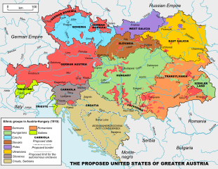
English: Ethnicities of Austria-Hungary, 1910 |
| Date | 21 December 2008 (original upload date) |
| Source |
Own work
Original uploader was ArdadN at en.wikipedia. Transferred from en.wikipedia; transferred to Commons by Avemundi using CommonsHelper. Bosnia-Herzegovina (annexed in 1908) was not considered in the first proposal map (1906). |
| Author | ArdadN |
| Other versions |
|
| SVG development |


.svg)


Licensing
| I, the copyright holder of this work, release this work into the
public domain. This applies worldwide. In some countries this may not be legally possible; if so: I grant anyone the right to use this work for any purpose, without any conditions, unless such conditions are required by law. |
File history
Click on a date/time to view the file as it appeared at that time.
| Date/Time | Thumbnail | Dimensions | User | Comment | |
|---|---|---|---|---|---|
| current | 08:50, 2 August 2010 |
| 1,360 × 1,052 (1.8 MB) | File Upload Bot (Magnus Manske) | {{BotMoveToCommons|en.wikipedia|year={{subst:CURRENTYEAR}}|month={{subst:CURRENTMONTHNAME}}|day={{subst:CURRENTDAY}}}} {{Information |Description={{en|Own work. Sources: 1. This map 200px for the ethnic groups |
File usage
The following pages on the English Wikipedia use this file (pages on other projects are not listed):
Global file usage
The following other wikis use this file:
- Usage on ast.wikipedia.org
- Usage on az.wikipedia.org
- Usage on cs.wikipedia.org
- Usage on cy.wikipedia.org
- Usage on de.wikipedia.org
- Usage on fr.wikipedia.org
- Usage on he.wikipedia.org
- Usage on hr.wikipedia.org
- Usage on id.wikipedia.org
- Usage on ja.wikipedia.org
- Usage on lmo.wikipedia.org
- Usage on pt.wikipedia.org
- Usage on ro.wikipedia.org
- Usage on ru.wikipedia.org
- Usage on sco.wikipedia.org
- Usage on sh.wikipedia.org
- Usage on sk.wikipedia.org
- Usage on sl.wikipedia.org
- Usage on uk.wikipedia.org
- Usage on vi.wikipedia.org
- Usage on zh.wikipedia.org