
Size of this preview:
680 × 599 pixels. Other resolutions:
272 × 240 pixels |
545 × 480 pixels |
872 × 768 pixels |
1,162 × 1,024 pixels |
1,280 × 1,128 pixels.
Original file (1,280 × 1,128 pixels, file size: 545 KB, MIME type: image/png)
| This is a file from the
Wikimedia Commons. Information from its
description page there is shown below. Commons is a freely licensed media file repository. You can help. |
Summary
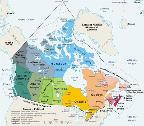
Español: Mapa político de
Canadá!, con 10 provincias y 3 territorios.
This is a geopolitical map of Canada, drawn by User:E Pluribus Anthony. Source: en:Image:Map Canada political-geo.png
| This work has been released into the
public domain by its author,
E Pluribus Anthony at
English Wikipedia. This applies worldwide. In some countries this may not be legally possible; if so: E Pluribus Anthony grants anyone the right to use this work for any purpose, without any conditions, unless such conditions are required by law. |
| Annotations | This image is annotated: View the annotations at Commons |
File history
Click on a date/time to view the file as it appeared at that time.
| Date/Time | Thumbnail | Dimensions | User | Comment | |
|---|---|---|---|---|---|
| current | 16:32, 5 May 2020 |
| 1,280 × 1,128 (545 KB) | Leonel Sohns | Edited |
| 02:18, 10 April 2006 |
 | 1,280 × 1,128 (493 KB) | E Pluribus Anthony~commonswiki | Map: Canada – geopolitical | |
| 18:31, 29 March 2006 |
 | 1,280 × 1,128 (494 KB) | Anchjo | This is a geopolitical map of Canada, drawn by en:User:E Pluribus Anthony. Source: en:Image:Map Canada political-geo.png {{PD-user-wikimedia|E Pluribus Anthony|en}} Category:Maps of Canada |
File usage
The following pages on the English Wikipedia use this file (pages on other projects are not listed):
Global file usage
The following other wikis use this file:
- Usage on ast.wikipedia.org
- Usage on cs.wikipedia.org
- Usage on de.wikipedia.org
- Usage on diq.wikipedia.org
- Usage on eo.wikipedia.org
- Usage on es.wikipedia.org
- Usage on fr.wikipedia.org
- Usage on gl.wikipedia.org
- Usage on it.wikipedia.org
- Usage on ko.wikipedia.org
- Usage on lfn.wikipedia.org
- Usage on mt.wikipedia.org
- Usage on mzn.wikipedia.org
- Usage on pl.wikipedia.org
- Usage on sw.wikipedia.org