
Size of this PNG preview of this SVG file:
469 × 600 pixels. Other resolutions:
188 × 240 pixels |
375 × 480 pixels |
600 × 768 pixels |
801 × 1,024 pixels |
1,601 × 2,048 pixels |
735 × 940 pixels.
Original file (SVG file, nominally 735 × 940 pixels, file size: 525 KB)
| This is a file from the
Wikimedia Commons. Information from its
description page there is shown below. Commons is a freely licensed media file repository. You can help. |
Summary
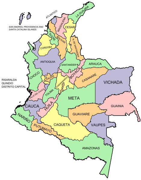
| Description | Map of Colombia with Departments |
| Date | |
| Source | Own work |
| Author | Camilo Sanchez |
Licensing
| I, the copyright holder of this work, release this work into the
public domain. This applies worldwide. In some countries this may not be legally possible; if so: I grant anyone the right to use this work for any purpose, without any conditions, unless such conditions are required by law. |
File history
Click on a date/time to view the file as it appeared at that time.
| Date/Time | Thumbnail | Dimensions | User | Comment | |
|---|---|---|---|---|---|
| current | 06:18, 30 October 2016 |
| 735 × 940 (525 KB) | Milenioscuro | boundaries |
| 06:48, 18 December 2009 |
 | 735 × 940 (246 KB) | Camilo Sanchez | {{Information |Description=Map of Colombia with Departments |Source=self-made |Date=December, 18, 2009 |Author= Camilo Sanchez |Permission= |other_versions= }} |
File usage
The following pages on the English Wikipedia use this file (pages on other projects are not listed):
- Colombia
- Departments of Colombia
- List of Colombian Department Assemblies
- Lists of Colombian department governors
- User:Camilo Sanchez/temps
- User:Jonny-mt/Gallery of current first-level administrative country subdivisions maps
- Wikipedia:Graphics Lab/Map workshop/Archive/Aug 2009
- Template:Colombia map clickable
Global file usage
The following other wikis use this file:
- Usage on awa.wikipedia.org
- Usage on ca.wikipedia.org
- Usage on co.wikimedia.org
- Usage on cs.wikipedia.org
- Usage on es.wikipedia.org
- Categoría:Departamentos de Colombia
- Categoría:Aeropuertos de Colombia por departamento
- Categoría:Emisoras de radio de Colombia por departamento
- Categoría:Historia de Colombia por departamento
- Usuario:Edwod2001/Plantillas
- Categoría:Hospitales de Colombia por departamento
- Categoría:Salud en Colombia por departamento
- Categoría:Geografía de Colombia por departamento
- Categoría:Economía de Colombia por departamento
- Categoría:Naturaleza de Colombia por departamento
- Categoría:Parques de Colombia por departamento
- Categoría:Colombianos por departamento
- Categoría:Cultura de Colombia por departamento
- Categoría:Política de Colombia por departamento
- Categoría:Sociedad de Colombia por departamento
- Categoría:Transporte de Colombia por departamento
- Categoría:Turismo en Colombia por departamento
- Categoría:Símbolos de Colombia por departamento
- Categoría:Religión en Colombia por departamento
- Categoría:Iglesias de Colombia por departamento
- Categoría:Obispos de Colombia por departamento
- Categoría:Museos de Colombia por departamento
- Categoría:Televisión de Colombia por departamento
- Categoría:Medios de comunicación de Colombia por departamento
- Categoría:Periódicos de Colombia por departamento
- Categoría:Festivales y ferias de Colombia por departamento
- Categoría:Universidades de Colombia por departamento
- Categoría:Educación en Colombia por departamento
- Categoría:Bibliotecas de Colombia por departamento
- Categoría:Deporte en Colombia por departamento
- Categoría:Edificios y estructuras de Colombia por departamento
- Categoría:Urbanismo de Colombia por departamento
- Categoría:Arquitectura de Colombia por departamento
- Categoría:Arte de Colombia por departamento
- Categoría:Edificios religiosos en Colombia por departamento
- Categoría:Centros comerciales de Colombia por departamento
- Categoría:Gobernadores de Colombia por departamento
- Categoría:Alcaldes de Colombia por departamento
- Categoría:Música de Colombia por departamento
- Categoría:Lagos de Colombia por departamento
- Plantilla:Mapa de Colombia clickeable
- Usage on eu.wikipedia.org
View more global usage of this file.