Photos • Location


Size of this preview:
304 × 600 pixels. Other resolutions:
121 × 240 pixels |
243 × 480 pixels |
824 × 1,625 pixels.
Original file (824 × 1,625 pixels, file size: 324 KB, MIME type: image/jpeg)
| This is a file from the
Wikimedia Commons. Information from its
description page there is shown below. Commons is a freely licensed media file repository. You can help. |
Summary
| Camera location |
| View this and other nearby images on: OpenStreetMap |
|
|---|
| Description |
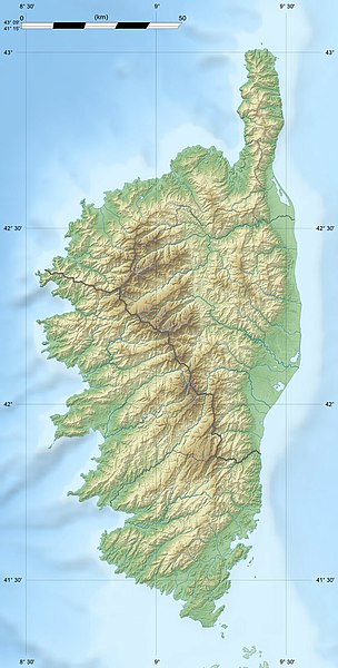
English: Blank physical map of the region of
Corsica, France, for geo-location purpose, with distinct boundaries for departments and arrondissements as they are since January 2010.
The former version of the map shows the boundaries as they were until December 2009. Français : Carte physique vierge de la région
Corse, France, destinée à la géolocalisation, avec limite distincte des départements et arrondissements tels que depuis janvier 2010. L' ancienne version de la carte montre le découpage administratif tel qu'il était jusqu'en décembre 2009. Scales: 1:520,000 (precision: 130 m) for the topography; 1:7,420,000 (precision: 1,855 m) for the bathymetry
Geographic limits of the map:
|
||
| Date | 2008-08, modified 02-2010 | ||
| Source |
Own work
|
||
| Author | Eric Gaba ( Sting - fr:Sting) | ||
| Permission ( Reusing this file) |
|
||
| Other versions |
|

Licensing
I, the copyright holder of this work, hereby publish it under the following licenses:
This file is licensed under the
Creative Commons
Attribution-Share Alike 3.0 Unported license.
- You are free:
- to share – to copy, distribute and transmit the work
- to remix – to adapt the work
- Under the following conditions:
- attribution – You must give appropriate credit, provide a link to the license, and indicate if changes were made. You may do so in any reasonable manner, but not in any way that suggests the licensor endorses you or your use.
- share alike – If you remix, transform, or build upon the material, you must distribute your contributions under the same or compatible license as the original.

|
Permission is granted to copy, distribute and/or modify this document under the terms of the GNU Free Documentation License, Version 1.2 or any later version published by the Free Software Foundation; with no Invariant Sections, no Front-Cover Texts, and no Back-Cover Texts. A copy of the license is included in the section entitled GNU Free Documentation License. |
You may select the license of your choice.
File history
Click on a date/time to view the file as it appeared at that time.
| Date/Time | Thumbnail | Dimensions | User | Comment | |
|---|---|---|---|---|---|
| current | 13:50, 18 July 2010 |
| 824 × 1,625 (324 KB) | Sting | Color profile |
| 18:33, 22 February 2010 |
 | 824 × 1,625 (317 KB) | Sting | Updated arrondissments boundaries of Haute-Corse | |
| 19:50, 14 August 2008 |
 | 824 × 1,625 (315 KB) | Sting | == Summary == {{Location|42|12|00|N|09|03|00|E|scale:2000000}} <br/> {{Information |Description={{en|Blank physical map of the region of Corsica, France, for geo-location purpose, with distinct boundaries for departments and arrondissement |
File usage
More than 100 pages use this file. The following list shows the first 100 pages that use this file only. A full list is available.
- Aiguilles de Bavella
- Calanques de Piana
- Cantone Grossu Tower
- Cavu
- Col de Vizzavona
- Col de la Croix (Corsica)
- Corsica
- Golo (river)
- Gravona
- Lac de Bettaniella
- Lac de Capitellu
- Lac de Goria
- Lac de Melu
- Lac de Nino
- Lac de l'Oriente
- Lac du Cinto
- List of Genoese towers in Corsica
- Monte Cinto
- Monte Grosso
- San Parteo
- Scandola Nature Reserve
- Taravo
- Tavignano
- Torra d'Agnellu
- Torra d'Albu
- Torra d'Alistru
- Torra d'Ancone
- Torra d'Asprettu
- Torra d'Omigna
- Torra d'Orchinu
- Torra di Caldanu
- Torra di Caldarellu
- Torra di Calvi
- Torra di Campumoru
- Torra di Capu Neru
- Torra di Capu di Fenu
- Torra di Castelluchju
- Torra di Fautea
- Torra di Ferringule
- Torra di Finochjarola
- Torra di Fiurentina
- Torra di Galeria
- Torra di Giraglia
- Torra di Grisgione
- Torra di Micalona
- Torra di Miomu
- Torra di Mortella
- Torra di Negru
- Torra di Nonza
- Torra di Padulella
- Torra di Pelusella
- Torra di Petranera
- Torra di Pianosa
- Torra di Pinareddu
- Torra di Poghju
- Torra di Portu
- Torra di Punta d'Arcu
- Torra di Roccapina
- Torra di Roglianu
- Torra di Sacru
- Torra di Sagone
- Torra di Saleccia
- Torra di San Pellegrinu
- Torra di Sant'Amanza
- Torra di Santa Maria Chjapella
- Torra di Scalu
- Torra di Seneca
- Torra di Senetosa
- Torra di Solenzara
- Torra di Spanu
- Torra di Sponsaglia
- Torra di Tizzà
- Torra di Toga
- Torra di Turghju
- Torra di Vignale
- Torra di a Castagna
- Torra di a Parata
- Torra di l'Isula di Gargali
- Torra di l'Isuledda
- Torra di l'Osse
- Tour d'Elbo
- Tour d'Erbalunga
- Tour d'Olmeto
- Tour de Bravone
- Tour de Capannella
- Tour de Capigliolo
- Tour de Capitello
- Tour de Capriona
- Tour de Cargèse
- Tour de Castellare
- Tour de Centuri
- Tour de Diana
- Tour de Girolata
- Tour de L'Île-Rousse
- Tour de Lozari
- Tour de Meria
- Tour de San Benedettu
- Tower of Capu di Muru
- Tower of San Ciprianu
- Turra di a Calanca
View more links to this file.
Global file usage
The following other wikis use this file:
- Usage on als.wikipedia.org
- Usage on ang.wikipedia.org
- Usage on ar.wikipedia.org
- Usage on ast.wikipedia.org
- Usage on bg.wikipedia.org
- Usage on bn.wikipedia.org
- Usage on bs.wikipedia.org
- Usage on ca.wikipedia.org
- Usage on ceb.wikipedia.org
- Usage on cs.wikipedia.org
- Usage on de.wikipedia.org
- Usage on de.wikivoyage.org
- Usage on dsb.wikipedia.org
- Usage on el.wikipedia.org
- Usage on eo.wikipedia.org
- Usage on es.wikipedia.org
View more global usage of this file.