
Original file (4,048 × 3,036 pixels, file size: 5.02 MB, MIME type: image/jpeg)
| This is a file from the
Wikimedia Commons. Information from its
description page there is shown below. Commons is a freely licensed media file repository. You can help. |
Summary
| Description |
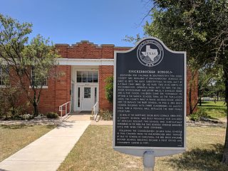
English: Texas State Historical Marker #2964
Knickerbocker Schools. Education for children in southwestern Tom Green County was available at Knickerbocker Schools as early as 1877. The Baze Subscription School, built by A. P. Baze (1833-1880) on his farm two miles north of Knickerbocker, operated from 1877 to 1899.The one-room schoolhouse had adobe walls, a shingled roof, and a pine floor. Children came on horseback to attend a six-month school term. As the population grew, the county built a frame schoolhouse about 1889 to replace the Baze School. In 1926 a red brick school building with three classrooms, an auditorium, and a central hall replaced the 1889 frame structure. In 1895, at the insistence of Dr. Boyd Cornick (1856-1933), a county school was built primarily for children of Mexican descent. This school was substantially remodeled in the 1930s. The two schools operated separately until 1948 when they were combined. Following the consolidation of area rural schools in 1960, children from the Knickerbocker area traveled by bus to school in Christoval. The red brick Knickerbocker school building became a post office and community center in 1989. (1992) #2964 FM 2335 & 584, Knickerbocker, TX, United States |
| Date | |
| Source | Own work |
| Author | Zoomie57 |
| Camera location | | View this and other nearby images on: OpenStreetMap |
|
|---|
Licensing
- You are free:
- to share – to copy, distribute and transmit the work
- to remix – to adapt the work
- Under the following conditions:
- attribution – You must give appropriate credit, provide a link to the license, and indicate if changes were made. You may do so in any reasonable manner, but not in any way that suggests the licensor endorses you or your use.
- share alike – If you remix, transform, or build upon the material, you must distribute your contributions under the same or compatible license as the original.
File history
Click on a date/time to view the file as it appeared at that time.
| Date/Time | Thumbnail | Dimensions | User | Comment | |
|---|---|---|---|---|---|
| current | 22:10, 7 May 2017 |
| 4,048 × 3,036 (5.02 MB) | Zoomie57 | User created page with UploadWizard |
File usage
Global file usage
The following other wikis use this file:
- Usage on www.wikidata.org