
Size of this preview:
508 × 599 pixels. Other resolutions:
203 × 240 pixels |
407 × 480 pixels |
651 × 768 pixels |
868 × 1,024 pixels |
1,737 × 2,048 pixels |
4,050 × 4,776 pixels.
Original file (4,050 × 4,776 pixels, file size: 2.21 MB, MIME type: image/png)
| This is a file from the
Wikimedia Commons. Information from its
description page there is shown below. Commons is a freely licensed media file repository. You can help. |
| Description |
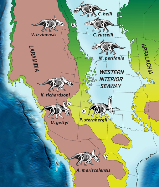
English: Paleogeography of North America during the Late Cretaceous (∼75 Ma), showing biogeographic distribution of chasmosaurine ceratopsid dinosaurs on the western landmass, Laramidia, during the late Campanian (∼76–73 Ma).
Green represents coastal and alluvial plain habitats and reddish brown represents highlands. Present day boundaries of states and provinces are noted, as are the locations of key dinosaur-bearing geologic formations. Abbreviations: A, Aguja Formation, Texas; D, Dinosaur Park Formation, Alberta; F, Fruitland-Kirtland Formations; K, Kaiparowits Formation, Utah). Modified after Blakey [1]. |
| Date | |
| Source | http://www.plosone.org/article/info%3Adoi%2F10.1371%2Fjournal.pone.0012292 |
| Author | Scott D. Sampson, Mark A. Loewen, Andrew A. Farke, Eric M. Roberts, Catherine A. Forster, Joshua A. Smith, Alan L. Titus |
| Permission ( Reusing this file) |
plos one |
|
This file is licensed under the
Creative Commons
Attribution 2.5 Generic license.
|
This file was published in a
Public Library of Science journal.
Their website
states that the content of all PLOS journals is published under the Creative Commons Attribution 4.0 license (or its previous version depending on the publication date), unless indicated otherwise.
|
File history
Click on a date/time to view the file as it appeared at that time.
| Date/Time | Thumbnail | Dimensions | User | Comment | |
|---|---|---|---|---|---|
| current | 11:07, 9 January 2014 |
| 4,050 × 4,776 (2.21 MB) | Trlkly | Removed white border and optimized. |
| 05:14, 8 January 2014 |
 | 4,096 × 4,821 (3.59 MB) | IJReid | {{subst:Upload marker added by en.wp UW}} {{Information |Description = {{en|Distribution of Campanian Chasmosaurines}} |Source = http://www.plosone.org/article/info%3Adoi%2F10.1371%2Fjournal.pone.0012292 |Date = September 22, 2010 |Author = Scott D. Sa... |
File usage
The following pages on the English Wikipedia use this file (pages on other projects are not listed):
Global file usage
The following other wikis use this file:
- Usage on de.wikipedia.org
- Usage on es.wikipedia.org
- Usage on it.wikipedia.org
- Usage on ja.wikipedia.org
- Usage on ko.wikipedia.org
- Usage on nl.wikipedia.org
- Usage on pt.wikipedia.org
- Usage on zh.wikipedia.org