Size of this preview:
800 × 566 pixels. Other resolutions:
320 × 226 pixels |
640 × 453 pixels |
1,024 × 724 pixels |
1,280 × 905 pixels |
2,560 × 1,811 pixels |
7,016 × 4,963 pixels.
Original file (7,016 × 4,963 pixels, file size: 2.95 MB, MIME type: image/jpeg)
| This is a file from the
Wikimedia Commons. Information from its
description page there is shown below. Commons is a freely licensed media file repository. You can help. |
Summary
| Description |
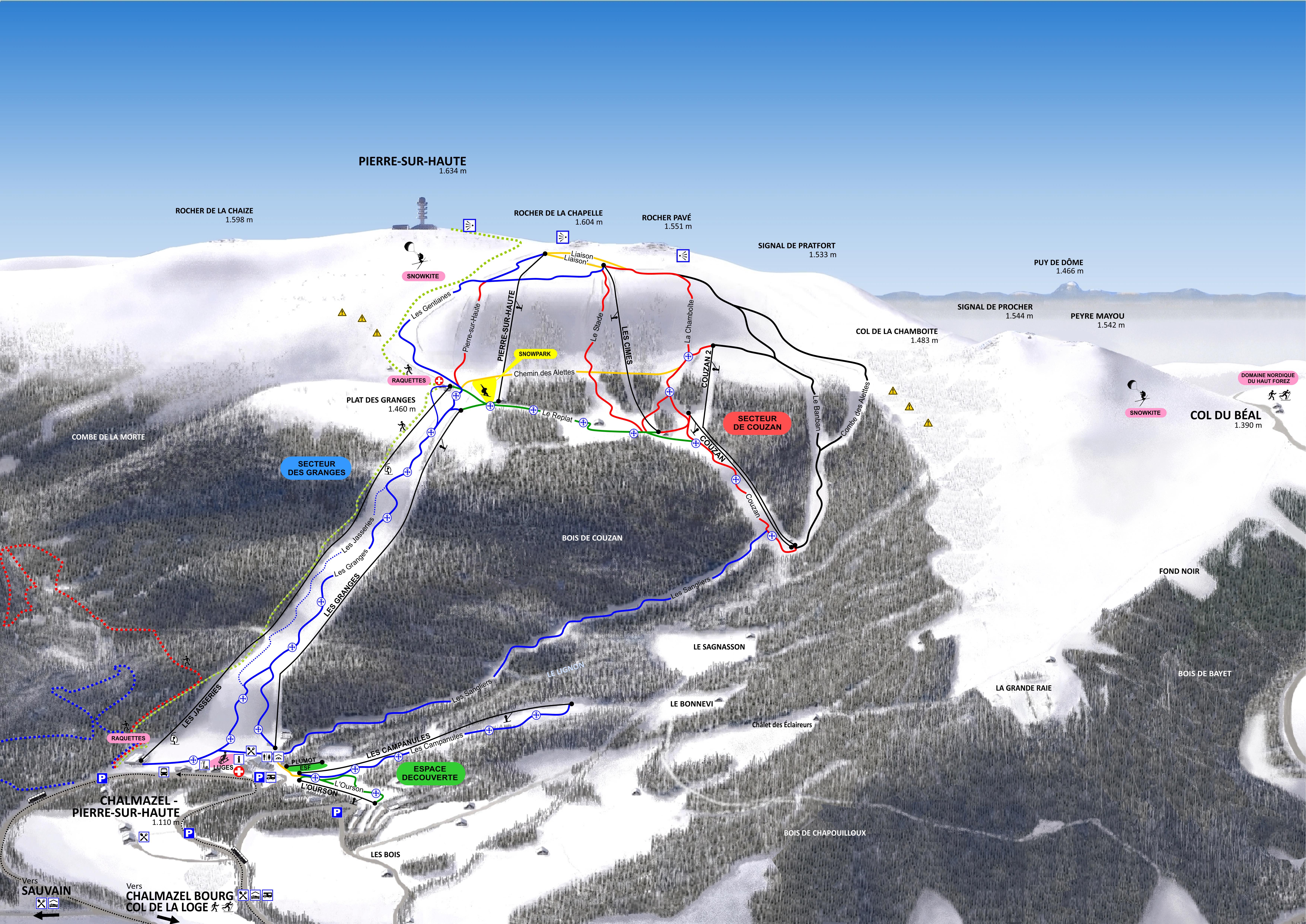
English: Map of Chalmazel Ski Resort
Français : Plan des pistes de Chalmazel |
| Source | Own work |
| Author | Laurent Berne |
Licensing
I, the copyright holder of this work, hereby publish it under the following license:
This file is licensed under the
Creative Commons
Attribution-Share Alike 3.0 Unported license.
- You are free:
- to share – to copy, distribute and transmit the work
- to remix – to adapt the work
- Under the following conditions:
- attribution – You must give appropriate credit, provide a link to the license, and indicate if changes were made. You may do so in any reasonable manner, but not in any way that suggests the licensor endorses you or your use.
- share alike – If you remix, transform, or build upon the material, you must distribute your contributions under the same or compatible license as the original.
File history
Click on a date/time to view the file as it appeared at that time.
| Date/Time | Thumbnail | Dimensions | User | Comment | |
|---|---|---|---|---|---|
| current | 09:00, 21 December 2017 |
| 7,016 × 4,963 (2.95 MB) | Lolo42 | Correction noms de sommets |
| 14:30, 19 December 2017 |
 | 7,016 × 4,963 (2.96 MB) | Lolo42 | Améliorations : - définition des lettres - fond de plan (végétation) - pictogrammes | |
| 09:43, 17 December 2017 |
 | 3,508 × 2,481 (1.07 MB) | Lolo42 | évolutions station saison 2017 | |
| 14:12, 12 March 2015 |
 | 3,299 × 2,291 (2.56 MB) | Lolo42 | Ajout Signal de Pratfort ; retouches | |
| 14:25, 9 March 2015 |
 | 3,175 × 2,308 (1.55 MB) | Lolo42 | Piste Granges bleue + retouche pistes liaison | |
| 10:24, 30 October 2014 |
 | 6,354 × 4,619 (5.16 MB) | Lolo42 | couleur piste Gentiannes | |
| 07:51, 28 June 2014 |
 | 6,354 × 4,619 (6.33 MB) | Lolo42 | Avec le détourage, c'est mieux. | |
| 07:45, 28 June 2014 |
 | 7,017 × 4,963 (2.88 MB) | Lolo42 | Snowpark + hébergements | |
| 13:31, 13 September 2013 |
 | 2,800 × 2,037 (3.28 MB) | Lolo42 | modif pictos | |
| 14:28, 6 September 2013 |
 | 2,800 × 2,036 (1.26 MB) | Lolo42 | oups correction altitudes |
File usage
The following pages on the English Wikipedia use this file (pages on other projects are not listed):
Global file usage
The following other wikis use this file: