
Size of this preview:
491 × 599 pixels. Other resolutions:
197 × 240 pixels |
393 × 480 pixels |
629 × 768 pixels |
839 × 1,024 pixels |
1,678 × 2,048 pixels |
7,181 × 8,764 pixels.
Original file (7,181 × 8,764 pixels, file size: 34.15 MB, MIME type: image/jpeg)
| This is a file from the
Wikimedia Commons. Information from its
description page there is shown below. Commons is a freely licensed media file repository. You can help. |
| Warning | The original file is very high-resolution. It might not load properly or could cause your browser to freeze when opened at full size. |
|---|
Summary
| Description |
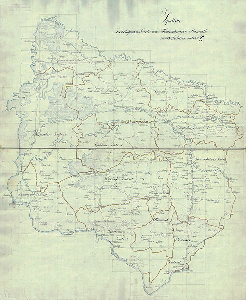
Deutsch: Das Banat in: Josephinische Landesaufnahme, 1769-72. English: The Banat region in the cadastral maps: Josephinische Landesaufnahme, 1769-72. |
||||
| Date | - 72 | ||||
| Source | Österreichisches Staatsarchiv, Kriegsarchiv | ||||
| Author | Historische Militärkarte der österreichisch-ungarischen Monarchie | ||||
| Permission ( Reusing this file) |
|
||||
Clickable map of the Banat region

File history
Click on a date/time to view the file as it appeared at that time.
| Date/Time | Thumbnail | Dimensions | User | Comment | |
|---|---|---|---|---|---|
| current | 07:13, 6 January 2010 |
| 7,181 × 8,764 (34.15 MB) | Asybaris01 | new rez |
| 06:57, 2 December 2009 |
 | 4,021 × 4,908 (18.34 MB) | Asybaris01 | {{Information |Description={{ro|1= Harta Iosefină a Banatului, 1769-72.}} |Source=Österreichisches Staatsarchiv, Kriegsarchiv |Author= Asybaris01 |Date=12/2/2009 |Permission= |other_versions= }} [[Category:Jose |
File usage
The following pages on the English Wikipedia use this file (pages on other projects are not listed):
Global file usage
The following other wikis use this file:
- Usage on de.wikipedia.org
- Usage on el.wikipedia.org
- Usage on hu.wikipedia.org