
Original file (1,235 × 935 pixels, file size: 307 KB, MIME type: image/jpeg)
| This is a file from the
Wikimedia Commons. Information from its
description page there is shown below. Commons is a freely licensed media file repository. You can help. |
Summary
| Description |
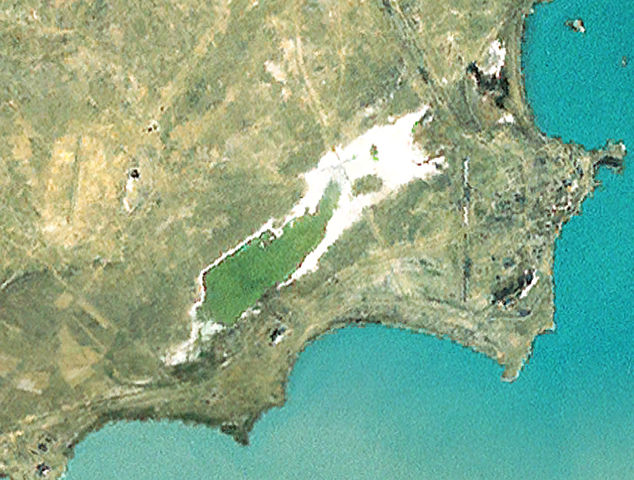
English: Public domain aerial photography of Balkhash-9 radar station in Kazakhstan. Photography is from the i-cubed landsat layer of NASA's World Wind.
Visible are the receiver and transmitter buildings of the Daryal radar, 4 demolished Dnestr radars and one functional Dnepr radar. The Dnepr is in the lower right corner of the land, it is the V-shaped object near the lakeshore. The remains of the original two Dnestr's (number 1 and 2) are arranged in a vertical line just to the left and above the Dnepr. These remain easily visible in this image. The townsite of Balkhash-9 is just to the right of these radars. The second pair of Dnestr's was built just above the originals. These are less visible in this photograph, running on an angle starting just above the upper radar of the original pair. The middle of one of them is just above the upper right tip of the dried-out portion of the pond, the second is visible at the very top of the image. The Daryal's receiver is the large white building just left of center, located between the lakeshore and the pond. Its transmitter is somewhat less visible in the very lower left corner of the image. |
| Date | |
| Source | NASA World Wind - i-cubed landsat |
| Author | NASA |
| Permission ( Reusing this file) |
PD |
Licensing
| This file is in the public domain in the United States because it was solely created by NASA. NASA copyright policy states that "NASA material is not protected by copyright unless noted". (See Template:PD-USGov, NASA copyright policy page or JPL Image Use Policy.) | ||
 |
Warnings:
|
| Annotations | This image is annotated: View the annotations at Commons |
File history
Click on a date/time to view the file as it appeared at that time.
| Date/Time | Thumbnail | Dimensions | User | Comment | |
|---|---|---|---|---|---|
| current | 02:31, 23 January 2012 |
| 1,235 × 935 (307 KB) | Secretlondon |
File usage
Global file usage
The following other wikis use this file: