
Size of this PNG preview of this SVG file:
440 × 366 pixels. Other resolutions:
289 × 240 pixels |
577 × 480 pixels |
923 × 768 pixels |
1,231 × 1,024 pixels |
2,462 × 2,048 pixels.
Original file (SVG file, nominally 440 × 366 pixels, file size: 187 KB)
| This is a file from the
Wikimedia Commons. Information from its
description page there is shown below. Commons is a freely licensed media file repository. You can help. |
Summary
File:
4U9525 flight path v1.svg has
2 translations.

Catalan

English


| Description |
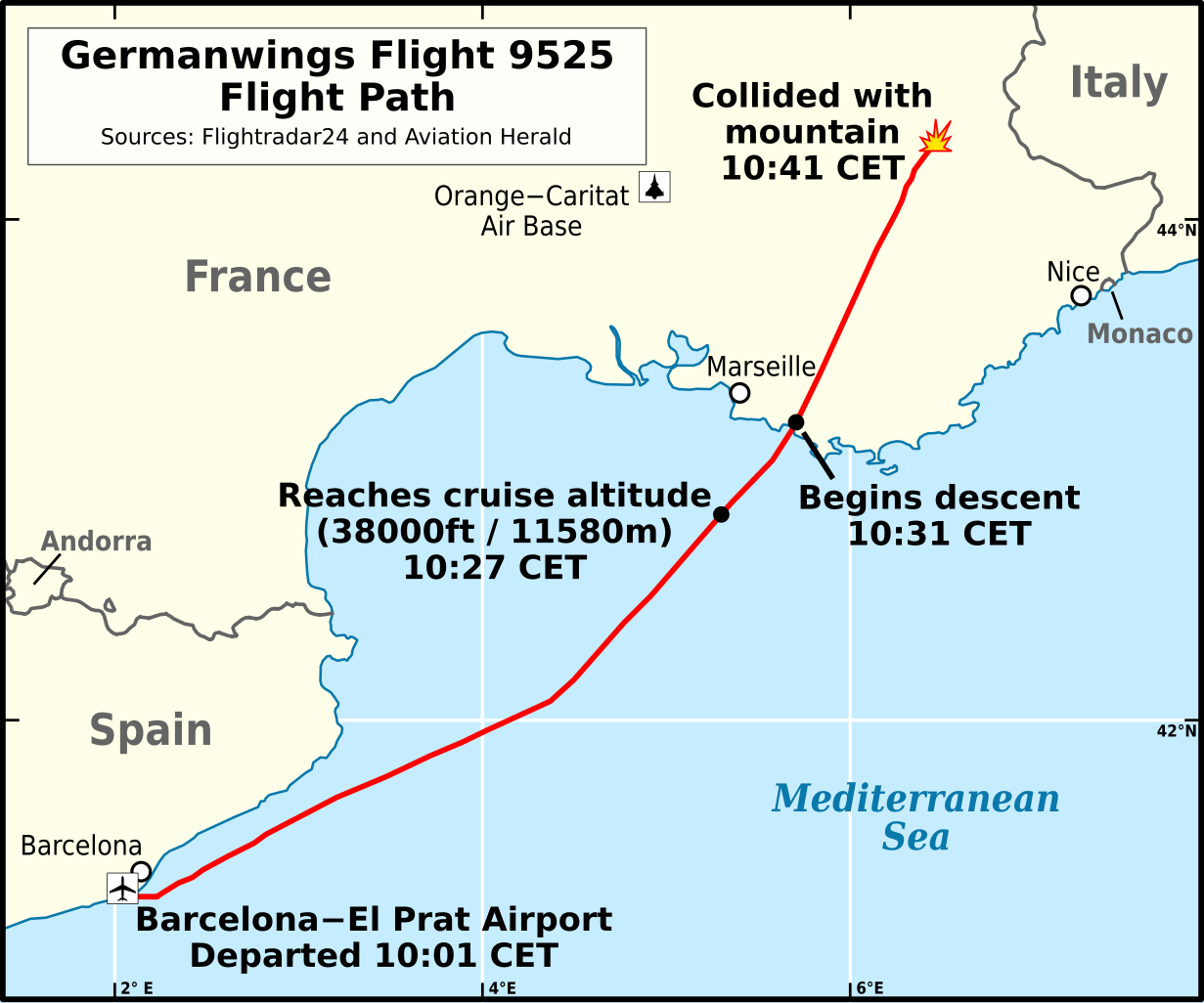
English: Flight path of
Germanwings Flight 9525 (English).
Català: Trajectòria de vol
Vol 9525 de Germanwings
Deutsch: Verlauf von
Germanwings-Flug 9525 (Englisch).
Español: Trayectoria de
Vuelo 9525 de Germanwings (Inglés).
Français : Trajectoire de vol
Vol 9525 Germanwings (Anglais) |
|||
| Date | ||||
| Source |
Own work based on:
|
|||
| Author | Andrew Heneen | |||
| Permission ( Reusing this file) |
I, the copyright holder of this work, hereby publish it under the following license: This file is licensed under the
Creative Commons
Attribution 4.0 International license.
|
|||
| Other versions | ||||
| SVG development |

File history
Click on a date/time to view the file as it appeared at that time.
| Date/Time | Thumbnail | Dimensions | User | Comment | |
|---|---|---|---|---|---|
| current | 12:28, 20 September 2023 |
| 440 × 366 (187 KB) | Lalpino | File uploaded using svgtranslate tool (https://svgtranslate.toolforge.org/). Added translation for ca. |
| 12:24, 20 September 2023 |
 | 440 × 366 (187 KB) | Lalpino | File uploaded using svgtranslate tool (https://svgtranslate.toolforge.org/). Added translation for ca. | |
| 10:11, 18 October 2020 |
 | 440 × 366 (173 KB) | Athozus | File uploaded using svgtranslate tool (https://svgtranslate.toolforge.org/). Added translation for fr. | |
| 21:34, 28 March 2015 |
 | 440 × 366 (171 KB) | AHeneen | Remove rivers, move map boundaries (further north, south, & west), add air base, change font size of event labels (10-->12) | |
| 11:10, 25 March 2015 |
 | 429 × 343 (166 KB) | AHeneen | decent-->descent | |
| 11:08, 25 March 2015 |
 | 429 × 343 (166 KB) | AHeneen | User created page with UploadWizard |
File usage
The following pages on the English Wikipedia use this file (pages on other projects are not listed):
Global file usage
The following other wikis use this file:
- Usage on af.wikipedia.org
- Usage on ca.wikipedia.org
- Usage on ca.wikinews.org
- Usage on cs.wikipedia.org
- Usage on en.wikinews.org
- Usage on et.wikipedia.org
- Usage on fa.wikipedia.org
- Usage on fr.wikinews.org
- Usage on ga.wikipedia.org
- Usage on hu.wikipedia.org
- Usage on it.wikipedia.org
- Usage on ko.wikipedia.org
- Usage on mr.wikipedia.org
- Usage on no.wikipedia.org
- Usage on oc.wikipedia.org
- Usage on pl.wikipedia.org
- Usage on pt.wikipedia.org
- Usage on ru.wikipedia.org
- Usage on sr.wikinews.org
- Usage on th.wikipedia.org
- Usage on tr.wikipedia.org
- Usage on uk.wikipedia.org