
Size of this preview:
511 × 600 pixels. Other resolutions:
204 × 240 pixels |
612 × 718 pixels.
Original file (612 × 718 pixels, file size: 99 KB, MIME type: image/jpeg)
| This is a file from the
Wikimedia Commons. Information from its
description page there is shown below. Commons is a freely licensed media file repository. You can help. |
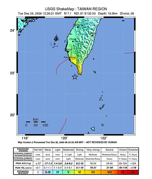
| Description | USGS map showing a major earthquake occurred 90 km (55 miles) SSE of Kao-hsiung, Taiwan and 795 km (495 miles) N of Manila, Philippines at 6:26 AM MDT, Dec 26, 2006 (8:26 PM local time in Taiwan). | |||
| Date | ||||
| Source | https://earthquake.usgs.gov/eqcenter/shakemap/global/shake/wtai_06/ | |||
| Author | USGS image | |||
| Permission ( Reusing this file) |
|
File history
Click on a date/time to view the file as it appeared at that time.
| Date/Time | Thumbnail | Dimensions | User | Comment | |
|---|---|---|---|---|---|
| current | 14:08, 12 June 2016 |
| 612 × 718 (99 KB) | Samchtt | update |
| 01:02, 4 April 2015 |
 | 612 × 716 (89 KB) | Dawnseeker2000 | This is the reviewed version | |
| 17:18, 26 December 2006 |
 | 530 × 680 (87 KB) | PFHLai | trim wide white edges | |
| 17:01, 26 December 2006 |
 | 612 × 718 (99 KB) | PFHLai | {{Information |Description= USGS map showing a major earthquake occurred 90 km (55 miles) SSE of Kao-hsiung, Taiwan and 795 km (495 miles) N of Manila, Philippines at 6:26 AM MDT, Dec 26, 2006 (8:26 PM local time in Taiwan). |Source= http://earthquake.us |
File usage
The following pages on the English Wikipedia use this file (pages on other projects are not listed):
Global file usage
The following other wikis use this file:
- Usage on ca.wikipedia.org
- Usage on de.wikipedia.org
- Usage on hu.wikipedia.org
- Usage on id.wikipedia.org
- Usage on sv.wikipedia.org
- Usage on zh.wikipedia.org