Photos • Location


| Fellhorn | |
|---|---|
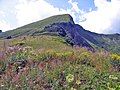
 The Fellhorn in summer | |
| Highest point | |
| Elevation | 2,038 m (6,686 ft) |
| Coordinates | 47°21′02″N 10°13′03″E / 47.35056°N 10.21750°E |
| Geography | |
 Fellhorn Location in the Alps | |
| Location | Germany / Austria |
| Parent range | Allgäu Alps |
| Climbing | |
| Easiest route | Hike |
The Fellhorn (2,038 metres (6,686 ft)) is a mountain in the " Allgäu Alps" near Oberstdorf, Germany, on the border with Austria. It is known for its fields of alpenroses ( Rhododendron ferrugineum). According to Austrian sources the mountain is 2,039 m above sea level (AA). [1]
Access
In 1972, a gondola lift, the " Fellhorn Lift", was built that runs up the mountain from the Stillach valley. Its top station is at 1,967 metres. There is also a lift connection to the Kanzelwandbahn. The cross-border Fellhorn/ Kanzelwand Ski Region has 24 kilometres of slopes and 14 lifts. [2]
Gallery
-
 The Fellhorn in winter
 -
 The summit from the east


References
- ^ Bundesamt für Eich- und Vermessungswesen Austria: Austrian Map online (Austrian 1:50,000 map series) Archived 2013-09-27 at the Wayback Machine. Retrieved 19 January 2011.
- ^ Skigebiet Fellhorn/Kanzelwand, retrieved 5 April 2012
External links
Wikimedia Commons has media related to
Fellhorn.