Photos • Location
Faladié | |
|---|---|
Village | |
| Coordinates: 13°8′20″N 8°20′16″W / 13.13889°N 8.33778°W | |
| Country | |
| Region | Koulikoro Region |
| Cercle | Kati Cercle |
| Commune | N'Tjiba |
| Elevation | 337 m (1,106 ft) |
| Time zone | UTC+0 ( GMT) |
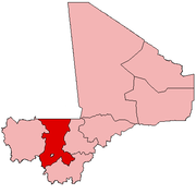
Faladié is a village and seat of the commune of N'Tjiba in the Cercle of Kati in the Koulikoro Region of south-western Mali. [1] The village lies 77 km northwest of the Malian capital, Bamako.
References
- ^ Communes de la Région de Koulikoro (PDF) (in French), Ministère de l’administration territoriale et des collectivités locales, République du Mali, archived from the original (PDF) on 2012-03-09.

