Photos • Location
Fânzeres | |
|---|---|
 | |
| Coordinates: 41°10′N 8°32′W / 41.167°N 8.533°W | |
| Country | |
| Region | Norte |
| Metropolitan area | Porto |
| District | Porto |
| Municipality | Gondomar |
| Disbanded | 2013 |
| Area | |
| • Total | 8.05 km2 (3.11 sq mi) |
| Population (2011) | |
| • Total | 23,108 |
| • Density | 2,900/km2 (7,400/sq mi) |
| Time zone | UTC±00:00 ( WET) |
| • Summer ( DST) | UTC+01:00 ( WEST) |
| Website | http://www.jf-fanzeres.pt/ |
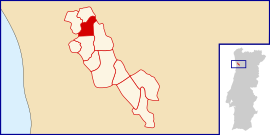
Fânzeres is a town and a former civil parish in the municipality of Gondomar, Portugal. In 2013, the parish merged into the new parish Fânzeres e São Pedro da Cova. [1] Its population is around 20,000.
References
- ^ Diário da República. "Law nr. 11-A/2013, page 552 53" (PDF) (in Portuguese). Retrieved 23 July 2014.
