Photos • Location


Erdeven
An Ardeven | |
|---|---|
 The Château of Kéravéon | |
.svg) Coat of arms | |
 Erdeven  Erdeven | |
| Coordinates: 47°38′N 3°10′W / 47.64°N 3.16°W | |
| Country | France |
| Region | Brittany |
| Department | Morbihan |
| Arrondissement | Lorient |
| Canton | Quiberon |
| Intercommunality | Auray Quiberon Terre Atlantique |
| Government | |
| • Mayor (2020–2026) | Dominique Riguidel [1] |
| Area 1 | 30.64 km2 (11.83 sq mi) |
| Population (2021)
[2] | 3,974 |
| • Density | 130/km2 (340/sq mi) |
| Time zone | UTC+01:00 ( CET) |
| • Summer ( DST) | UTC+02:00 ( CEST) |
| INSEE/Postal code |
56054 /56410 |
| Elevation | 0–36 m (0–118 ft) (avg. 20 m or 66 ft) |
| 1 French Land Register data, which excludes lakes, ponds, glaciers > 1 km2 (0.386 sq mi or 247 acres) and river estuaries. | |
Erdeven (French pronunciation: [ɛʁdəvɛn]; Breton: An Ardeven) is a commune in the Morbihan department in the region of Brittany in north-western France. [3]
Its main industry is tourism. Attractions include a seven kilometre-long beach beside the Atlantic and many prehistoric sites featuring megaliths. The Mané-Croch, Mané-Bras and Crucuno dolmens and the Kerzérho alignments lie just outside the commune.
Population
| Year | Pop. | ±% p.a. |
|---|---|---|
| 1968 | 1,910 | — |
| 1975 | 1,986 | +0.56% |
| 1982 | 2,145 | +1.11% |
| 1990 | 2,352 | +1.16% |
| 1999 | 2,523 | +0.78% |
| 2007 | 3,240 | +3.18% |
| 2012 | 3,488 | +1.49% |
| 2017 | 3,666 | +1.00% |
| Source: INSEE [4] | ||
Inhabitants of Erdeven are called Erdevenois in French.
Twin towns
It is twinned with St. Märgen in the Black Forest region of Germany.
Gallery
-
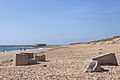 Kerouriec beach in Erdeven
 -
 The “ Kerzérho Giants” in Erdeven


See also
References
- ^ "Maires du Morbihan" (PDF). Préfecture du Morbihan. 7 July 2020.
- ^ "Populations légales 2021". The National Institute of Statistics and Economic Studies. 28 December 2023.
- ^ INSEE commune file
- ^ Population en historique depuis 1968, INSEE
External links
Wikimedia Commons has media related to
Erdeven.
- Official commune website (in French)
- Erdeven's Office of Tourism website (in French)
- Cultural Heritage (in French)
- Erdeven on bretagne.com
| International | |
|---|---|
| National | |
|
| This Morbihan geographical article is a stub. You can help Wikipedia by expanding it. |