Photos • Location
This article needs additional citations for
verification. (May 2024) |
El Cubo de Tierra del Vino, Spain | |
|---|---|
|
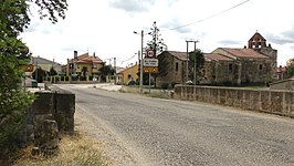
Top down: view of El Cubo, City Hall and parish church. | |
| Nickname: El Cubo del Vino | |
| Country | |
| Autonomous community | |
| Province | |
| Municipality | El Cubo de Tierra del Vino |
| Area | |
| • Total | 33 km2 (13 sq mi) |
| Population (2018)
[1] | |
| • Total | 320 |
| • Density | 9.7/km2 (25/sq mi) |
| Time zone | UTC+1 ( CET) |
| • Summer ( DST) | UTC+2 ( CEST) |
| Website | www.cubodelvino.es |
El Cubo de Tierra del Vino is a municipality located in the province of Zamora, Castile and León, Spain. According to the 2009 census ( INE), the municipality has a population of 429 inhabitants.
It was probably the city named Sabaria in some chronicles of the Roman age.
References
- ^ Municipal Register of Spain 2018. National Statistics Institute.


