Dry Run, Pennsylvania | |
|---|---|
Unincorporated community | |
| Coordinates: 40°10′3″N 77°45′14″W / 40.16750°N 77.75389°W | |
| Country | United States |
| State | Pennsylvania |
| County | Franklin |
| Township | Fannett |
| Elevation | 902 ft (275 m) |
| Time zone | UTC-5 ( Eastern (EST)) |
| • Summer ( DST) | UTC-4 (EDT) |
| ZIP code | 17220 |
| Area code | 717 |
| GNIS feature ID | 1173525 [1] |
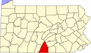
Dry Run is an unincorporated community in Fannett Township in Franklin County, Pennsylvania, United States. Dry Run is located at the intersection of Pennsylvania Route 75 and Back Road. [2]
Dry Run was originally called Morrowstown, and under the latter name was platted in 1838, and named after the maiden name of the founder's wife. [3] The present name is derived from nearby Dry Run creek. [3] A post office called Dry Run has been in operation since 1825. [4]
References
- ^ "Dry Run". Geographic Names Information System. United States Geological Survey, United States Department of the Interior.
- ^ Franklin County, Pennsylvania Highway Map (PDF) (Map). PennDOT. 2015. Retrieved January 2, 2016.
- ^ a b M'Cauley, I. H. (1878). Historical Sketch of Franklin County, Pennsylvania. Patriot. p. 207.
- ^ "Franklin County". Jim Forte Postal History. Retrieved June 19, 2017.


