Photos • Location
Diffa | |
|---|---|
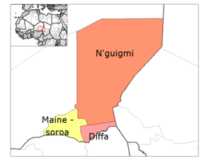
 Diffa Department location in the region | |
| Country |
|
| Region | Diffa Region |
| Area | |
| • Total | 2,071 sq mi (5,365 km2) |
| Population (2012) | |
| • Total | 159,722 |
| Time zone | UTC+1 (GMT 1) |
Diffa is a department of the Diffa Region in the extreme southeast of Niger. It is bordered by Chad to the east. Its capital lies at the city of Diffa. As of 2012, the department had a population of 209,249 people. [1] [2] [3]
Communes
References
- ^ "Niger: Municipal Division (Departments and Communes) - Population Statistics, Charts and Map". www.citypopulation.de. Retrieved 2024-02-22.
- ^ "Annuaires_Statistiques" (PDF). Institut National de la Statistique. Retrieved 2 May 2013.
- ^ "NIGER: Diffa Region". Archived from the original on 2019-07-03. Retrieved 2020-03-05.
13°18′55″N 12°36′40″E / 13.31528°N 12.61111°E