Photos • Location
Denklingen | |
|---|---|
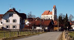
 Church of Saint Michael in Denklingen | |
Location of Denklingen within Landsberg am Lech district  | |
| Coordinates: 47°55′N 10°51′E / 47.917°N 10.850°E | |
| Country | Germany |
| State | Bavaria |
| Admin. region | Oberbayern |
| District | Landsberg am Lech |
| Subdivisions | 3 Ortsteile |
| Government | |
| • Mayor (2023–29) | Andreas Braunegger [1] |
| Area | |
| • Total | 56.76 km2 (21.92 sq mi) |
| Elevation | 708 m (2,323 ft) |
| Population (2022-12-31)
[2] | |
| • Total | 2,913 |
| • Density | 51/km2 (130/sq mi) |
| Time zone | UTC+01:00 ( CET) |
| • Summer ( DST) | UTC+02:00 ( CEST) |
| Postal codes | 86920 |
| Dialling codes | 08243 (Denklingen) 08869 (Epfach) |
| Vehicle registration | LL |
| Website | www.denklingen.de |
Denklingen is a municipality in the district of Landsberg (also called Landsberg am Lech) in Bavaria in Germany. The former municipality of Epfach, which has a history back to the Roman period, is now part of Denklingen.
Geography
Denklingen is the most southwesterly municipality in the district of Landsberg. It is located on flats to the west of the Lech River. It is at the edge of Denklinger Rotwalds (red forest of Denklingen) and Sachsenrieder forest.
References
- ^ Liste der ersten Bürgermeister/Oberbürgermeister in kreisangehörigen Gemeinden, Bayerisches Landesamt für Statistik. Retrieved 13 June 2024.
- ^ Genesis Online-Datenbank des Bayerischen Landesamtes für Statistik Tabelle 12411-003r Fortschreibung des Bevölkerungsstandes: Gemeinden, Stichtag (Einwohnerzahlen auf Grundlage des Zensus 2011).


