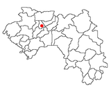
Photos • Location
Daralabe | |
|---|---|
Sub-prefecture and town | |
| Coordinates: 11°26′N 11°21′W / 11.433°N 11.350°W | |
| Country | |
| Region | Labé Region |
| Prefecture | Labé Prefecture |
| Time zone | UTC+0 ( GMT) |
Daralabe ( Pular: 𞤂𞤫𞤧-𞤯𞤢𞤤𞤭𞥅𞤪𞤫 𞤁𞤢𞥄𞤪𞤢 𞤂𞤢𞤦𞤫) is a town and sub-prefecture in the Labé Prefecture in the Labé Region of northern-central Guinea. [1]
It is situated between the sub-prefecture of Garambe, Hafia and Bantighel. It is divided into six Districts: Dara-Centre, Gaya, Madina N'Dire, Daraketchoun, Kouraba and Fello Bantang
References
- ^ "Subprefectures of Guinea". Statoids. Retrieved April 19, 2009.
11°26′N 11°21′W / 11.433°N 11.350°W

