The Daen Lao Range (
Thai: ทิวเขาแดนลาว,[1]pronounced[tʰīwkʰǎwdɛ̄ːnlāːw];
Burmese: Loi La) is a mountain range of the
Shan Hills in eastern
Burma and northern
Thailand. Most of the range is in
Shan State, with its northern limit close to the border with
China, and runs southwards across the Thai border, at the northern end of Thailand.
Geologically in the Daen Lao Range, as in the other southern subranges of the Shan Hills, layers of
alluvium are superimposed on hard rock.[2]
Geography
The range extends east of the
Salween until almost reaching the
Golden Triangle area, separating the Salween watershed from the
Mekong watershed. At its southern end the
Thanon Thong Chai Range (เทือกเขาถนนธงชัย) subrange stretches further southwards into Thailand between the
Sai River in the east and the
Pai River in the west; the latter separating the Daen Lao from the Thanon Thong Chai Range.[1] Some geographers include the Thanon Thong Chai Range subrange as part of the Daen Lao Range.[3] The
Khun Tan Range also extends southwards from the Daen Lao Range, parallel to the Thanon Thong Chai mountains, but it differs geologically and structurally from the latter.
Historically the area has been sparsely populated. Only some
hill tribes such as the
Wa,
Akha,
Yao,
Lahu, and the
Lisu people lived in scattered small villages across the range.[8]
Until the 1990s one of the main crops at elevations above 1,000 m was
opium. On the side of the range controlled by the Thai government, construction of roads reaching remote areas and increasingly efficient policing ensured a measure of success of the
opium replacement programs in recent years.[10]
Owing to the unrest in Burma, the
National Democratic Alliance Army (NDAA) and other groups sought refuge and a base for their
insurgency in these mountains. Fighting and the ensuing persecution by the
Tatmadaw[11] have caused part of the original population to flee. Some
refugee camps have been established for cross-border refugees on the Thai side of the range. Some
Kayah and
Karen communities, like the "long-necked Karen", are regularly visited by organized tourist groups.[12]
The
Ang Khang Royal Agricultural Station is in the mountains of the range. It was founded in 1969 by the
King of Thailand and is notable for its temperate climate that allows the cultivation of flowers and fruits characteristic of cooler climates.[13]
In March 2011 there was a magnitude 5
earthquake in the Burmese side of the range with the
epicenter north of
Chiang Rai town. There were over 70 deaths and more than hundred wounded.[14]
 Looking out over Burma from Thailand, into the heart of the range
![Wat Phra That Doi Wao [th] and the Daen Lao Range, Thai highlands](https://upload.wikimedia.org/wikipedia/commons/thumb/0/01/Wat_Phra_Dhatu_Doi_Wao_%E0%B8%A7%E0%B8%B1%E0%B8%94%E0%B8%9E%E0%B8%A3%E0%B8%B0%E0%B8%98%E0%B8%B2%E0%B8%95%E0%B8%B8%E0%B8%94%E0%B8%AD%E0%B8%A2%E0%B9%80%E0%B8%A7%E0%B8%B2_%28October_2021%29_-_img_07.jpg/195px-Wat_Phra_Dhatu_Doi_Wao_%E0%B8%A7%E0%B8%B1%E0%B8%94%E0%B8%9E%E0%B8%A3%E0%B8%B0%E0%B8%98%E0%B8%B2%E0%B8%95%E0%B8%B8%E0%B8%94%E0%B8%AD%E0%B8%A2%E0%B9%80%E0%B8%A7%E0%B8%B2_%28October_2021%29_-_img_07.jpg) Wat Phra That Doi Wao and the Daen Lao Range, Thai highlands
Wat Phra That Doi Wao and the Daen Lao Range, Thai highlands The eastern end of the town of Santikhiri at Doi Mae Salong
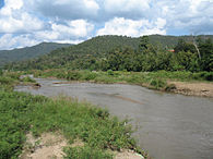 The range above the Pai River in Pai District. This river has its source in the SW of the range
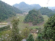 Ang Khang Royal Agricultural Station
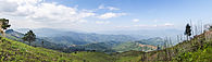
 View from Rte 1340 in Chai Prakan District


![Wat Phra That Doi Wao [th] and the Daen Lao Range, Thai highlands](/info/en/?search=File:Wat_Phra_Dhatu_Doi_Wao_%E0%B8%A7%E0%B8%B1%E0%B8%94%E0%B8%9E%E0%B8%A3%E0%B8%B0%E0%B8%98%E0%B8%B2%E0%B8%95%E0%B8%B8%E0%B8%94%E0%B8%AD%E0%B8%A2%E0%B9%80%E0%B8%A7%E0%B8%B2_(October_2021)_-_img_07.jpg)


