Corcubión (
AGAL ortography: Corcubiom) is a municipality in the province of
A Coruña, in the autonomous community of
Galicia,
Spain. It belongs to the
comarca of
Fisterra.
It is located on the river with the same name.
View from the promenade
History
Corcubión belonged to the county of Traba, but later passed into the hands of the Count of Altamira.
Linguistic status
The local government of the municipality was the first public institution to officially use the
AGAL norm[citation needed] of the
Galician language according to the
Reintegrationism ideas, as seen in its website, offering options for "Galician" (
NOMIGa) and "
Galician-Portuguese" (AGAL), as well as Spanish and English.

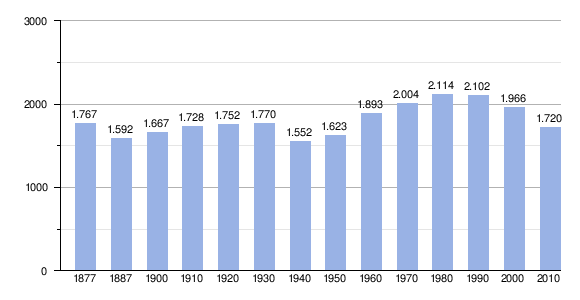 From:
INE Archiv
From:
INE Archiv


