Photos • Location
Confluence Commercial Historic District | |
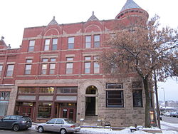
 Drummond-Cameron Block at the corner of Eau Claire and Barstow Streets | |
| Location | Eau Claire, Wisconsin |
|---|---|
| Coordinates | 44°48′44″N 91°30′2″W / 44.81222°N 91.50056°W |
| NRHP reference No. | 07001047 |
| Added to NRHP | October 3, 2007 |
The Confluence Commercial Historic District is located in Eau Claire, Wisconsin. It was added to the National Register of Historic Places in 2007. [1]
History
The area was first populated by French Canadian immigrants. Contributing buildings in the district were constructed from 1861 to 1936. [2]
References
- ^ "Confluence Commercial Historic District". Landmark Hunter.com. Retrieved February 13, 2012.
- ^ "Confluence Commercial Historic District". Wisconsin Historical Society. Retrieved February 13, 2012.

