Photos • Location
Conceição | |
|---|---|
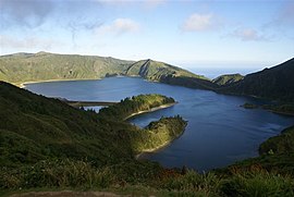
 The northern margin of Lagoa do Fogo (foreground), on the southern border of the parish | |
| Coordinates: 37°49′7″N 25°31′35″W / 37.81861°N 25.52639°W | |
| Country | |
| Auton. region | Azores |
| Island | São Miguel |
| Municipality | Ribeira Grande |
| Area | |
| • Total | 12.73 km2 (4.92 sq mi) |
| Elevation | 28 m (92 ft) |
| Population (2011) | |
| • Total | 2,425 |
| • Density | 190/km2 (490/sq mi) |
| Time zone | UTC−01:00 (AZOT) |
| • Summer ( DST) | UTC±00:00 (AZOST) |
| Postal code | 9600-538 |
| Area code | 292 |
| Patron | Nossa Senhora da Conceição |
| Website |
www |
Conceição is a freguesia ("civil parish") in the district of Ribeira Grande in the Azores. The population in 2011 was 2,425, [1] in an area of 12.73 km². [2] It is situated on the north coast of the island. Together with the parish Matriz, it forms the old core of the town Ribeira Grande. It contains the localities Caldeiras and Conceição.
References
- ^ Instituto Nacional de Estatística
- ^ Eurostat Archived September 6, 2014, at the Wayback Machine

