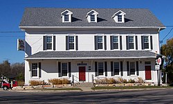
Photos • Location
Club Harbor | |
 Club Harbor | |
| Location | Jct. of WI 151 and WI W, Pipe, Wisconsin |
|---|---|
| Coordinates | 43°54′51″N 88°18′50″W / 43.91417°N 88.31389°W |
| Area | 1.2 acres (0.49 ha) |
| Built | 1846 |
| Architectural style | Greek Revival |
| NRHP reference No. | 80000135 [1] |
| Added to NRHP | January 22, 1980 |
Club Harbor is located in Pipe, Wisconsin.
The building was opened as a stagecoach stop. In large part, it served those travelling along a military road connecting Fort Howard and Fort Winnebago. Beginning in 1856, it was operated by Jacob Fuhrman. The building was listed on the National Register of Historic Places in 1980 and on the State Register of Historic Places in 1989. [2]
- ^ "National Register Information System". National Register of Historic Places. National Park Service. November 2, 2013.
- ^ "NW CORNER STATE HIGHWAY 151 AND COUNTY HIGHWAY W". Wisconsin Historical Society. Retrieved 2018-08-28.
Categories:
- Stagecoach stations on the National Register of Historic Places
- Hotel buildings on the National Register of Historic Places in Wisconsin
- National Register of Historic Places in Fond du Lac County, Wisconsin
- Greek Revival architecture in Wisconsin
- Brick buildings and structures in Wisconsin
- Hotel buildings completed in 1846