Photos • Location


You can help expand this article with text translated from
the corresponding article in French. (December 2009) Click [show] for important translation instructions.
|
Cessieu | |
|---|---|
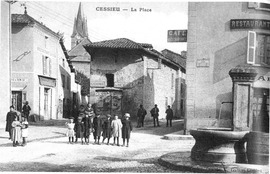 The village square in 1925 | |
 Coat of arms | |
 Cessieu  Cessieu | |
| Coordinates: 45°34′03″N 5°22′39″E / 45.5675°N 5.3775°E | |
| Country | France |
| Region | Auvergne-Rhône-Alpes |
| Department | Isère |
| Arrondissement | La Tour-du-Pin |
| Canton | La Tour-du-Pin |
| Government | |
| • Mayor (2020–2026) | Christophe Brochard [1] |
| Area 1 | 14.35 km2 (5.54 sq mi) |
| Population (2021)
[2] | 3,244 |
| • Density | 230/km2 (590/sq mi) |
| Time zone | UTC+01:00 ( CET) |
| • Summer ( DST) | UTC+02:00 ( CEST) |
| INSEE/Postal code |
38064 /38110 |
| Elevation | 278–508 m (912–1,667 ft) (avg. 309 m or 1,014 ft) |
| 1 French Land Register data, which excludes lakes, ponds, glaciers > 1 km2 (0.386 sq mi or 247 acres) and river estuaries. | |
Cessieu (French pronunciation: [sɛsjø]) is a commune in the Isère department in south-eastern France.
Geography
The Bourbre flows west through the middle of the commune and crosses the village.
Population
|
| ||||||||||||||||||||||||||||||||||||||||||||||||||||||||||||||||||||||||||||||||||||||||||||||||||||||||||||||||||
| Source: EHESS [3] and INSEE (1968-2017) [4] | |||||||||||||||||||||||||||||||||||||||||||||||||||||||||||||||||||||||||||||||||||||||||||||||||||||||||||||||||||
Twin towns
Cessieu is twinned with:
-
 Civitella Roveto, Italy, since 2004
See also
References
- ^ "Répertoire national des élus: les maires". data.gouv.fr, Plateforme ouverte des données publiques françaises (in French). 2 December 2020.
- ^ "Populations légales 2021" (in French). The National Institute of Statistics and Economic Studies. 28 December 2023.
- ^ Des villages de Cassini aux communes d'aujourd'hui: Commune data sheet Cessieu, EHESS (in French).
- ^ Population en historique depuis 1968, INSEE
Wikimedia Commons has media related to
Cessieu.
| Authority control databases: National |
|---|
|
| This Isère geographical article is a stub. You can help Wikipedia by expanding it. |