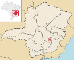
Photos • Location
From Wikipedia, the free encyclopedia
Municipality in Southeast, Brazil
Catas Altas | |
|---|---|
| Municipality of Catas Altas | |
 | |
| Country | |
| Region | Southeast |
| State | |
| Founded | 8 December 1703 |
| Government | |
| • Mayor | Saulo Morais ( PATRI) |
| Area | |
| • Total | 240.042 km2 (92.681 sq mi) |
| Elevation | 745 m (2,444 ft) |
| Population (2021)
[1] | |
| • Total | 5,465 |
| • Density | 20.19/km2 (52.3/sq mi) |
| Demonym | catas-altense |
| Time zone | UTC−3 ( BRT) |
| HDI (2010) | 0.684 – medium [2] |
| Website |
www |
Catas Altas is a Brazilian municipality located in the state of Minas Gerais. The city belongs to the mesoregion Metropolitana de Belo Horizonte and to the microregion of Itabira. As of 2020, the estimated population was 5,421. [3]
See also
References
- ^ "IBGE Catas Altas". IBGE. Retrieved 10 April 2022.
-
^
"Archived copy" (PDF).
United Nations Development Programme (UNDP). Archived from
the original (PDF) on July 8, 2014. Retrieved August 1, 2013.
{{
cite web}}
: CS1 maint: archived copy as title ( link) - ^ IBGE 2020
20°4′30″S 43°24′28″W / 20.07500°S 43.40778°W / -20.07500; -43.40778
| International | |
|---|---|
| National | |
|
| This geographical article relating to Minas Gerais is a stub. You can help Wikipedia by expanding it. |
Retrieved from "
https://en.wikipedia.org/?title=Catas_Altas&oldid=1209207905"
Hidden categories:
- CS1 maint: archived copy as title
- Pages using gadget WikiMiniAtlas
- Articles with short description
- Short description is different from Wikidata
- Pages using multiple image with auto scaled images
- Pages using infobox settlement with no coordinates
- Coordinates on Wikidata
- Articles with VIAF identifiers
- Articles with J9U identifiers
- Articles with LCCN identifiers
- All stub articles


