Photos • Location
| Brokke Power Station | |
|---|---|
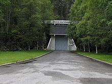
 Entrance to the Brokke Power Station | |
| Official name | Brokke kraftverk |
| Country | Norway |
| Location | Valle |
| Coordinates | 59°07′41″N 7°30′50″E / 59.128°N 7.514°E |
| Status | In use |
| Opening date | 1965 |
| Owner(s) | Otra Kraft |
| Power Station | |
| Hydraulic head | 303 metres (994 ft) |
| Installed capacity | 330 MW |
| Capacity factor | 59.8% |
| Annual generation | 1,416 GW·h |
The Brokke Power Station is a hydroelectric power station located in the municipality Valle in Agder county, Norway. It is located on the west shore of the river Otra, about 4 kilometres (2.5 mi) north of the village of Rysstad. The Norwegian National Road 9 runs past the station. The facility operates at an installed capacity of 330 megawatts (440,000 hp). The average annual production is 1,416 gigawatt-hours (5,100 TJ). The power station receives its water from the lake Botnsvatnet via a 30-kilometre (19 mi) long tunnel from the lake high up in the mountains. The water flowing down through the tunnel is used to produce the hydroelectric power. [1]
References
- ^ Henriksen, Petter (ed.). "Brokke". Store norske leksikon (in Norwegian). Oslo: Kunnskapsforlaget. Retrieved 15 August 2011.