Rummelsburg | |
|---|---|
 Tuchollaplatz (
Victoriastadt) | |
Location of Rummelsburg in Lichtenberg district and Berlin  | |
 Rummelsburg  Rummelsburg | |
| Coordinates: 52°30′00″N 13°29′33″E / 52.50000°N 13.49250°E | |
| Country | Germany |
| State | Berlin |
| City | Berlin |
| Borough | Lichtenberg |
| Founded | 1669 |
| Subdivisions | 1 zone |
| Area | |
| • Total | 4.52 km2 (1.75 sq mi) |
| Elevation | 50 m (160 ft) |
| Population (2020-12-31)
[1] | |
| • Total | 25,697 |
| • Density | 5,700/km2 (15,000/sq mi) |
| Time zone | UTC+01:00 ( CET) |
| • Summer ( DST) | UTC+02:00 ( CEST) |
| Postal codes | (nr. 1112) 10317 |
| Vehicle registration | B |
Rummelsburg (German: [ˈʁʊml̩sˌbʊʁk] ) is a subdivision or neighborhood (Ortsteil) of the borough (Bezirk) of Lichtenberg of the German capital, Berlin.
History
Rummelsburg was founded in 1669. On 30 January 1889 it became a rural municipality, with the name of Boxhagen-Rummelsburg. Merged in 1912 in the town of Lichtenberg, in 1920 it was incorporated in Berlin with the Greater Berlin Act. [2]
Geography
Overview
Located in the eastern side of the city and crossed by Spree river in the western corner, Rummelsburg borders with Lichtenberg, Friedrichsfelde, Karlshorst, Friedrichshain (in Friedrichshain-Kreuzberg district), Plänterwald and Oberschöneweide (both in Treptow-Köpenick district). The lake Rummelsburger See belongs to the locality and separates it from Stralau, a zone of Friedrichshain.
Subdivision
Rummelsburg counts 1 zone (Ortslage):
Transport
The locality is served by several urban rail lines of S-Bahn and U-Bahn. The stations serving the locality are Rummelsburg ( S3 line), Betriebsbahnhof Rummelsburg (S3), Nöldnerplatz ( S5, S7, S75), partly Ostkreuz ( S3, S4, S5, S7, S75, S8, S85, S9) and part of the DB station of Lichtenberg (S5, S7, S75, U5, Tram).
Personalities
- Adolph Schlicht (1840–1910)
- Heinrich Zille (1858–1929)
- Margarete Steffin (1908–1941)
Photogallery
-
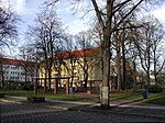
 Nöldnerplatz
 -
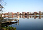 The Rummelsburger See
 -
 Münsterlandplatz
 -


References
- ^ "Einwohnerinnen und Einwohner im Land Berlin am 31. Dezember 2020" (PDF). Amt für Statistik Berlin-Brandenburg. February 2021.
- ^ (in German) Historical infos about Rummelsburg
External links
![]() Media related to
Rummelsburg at Wikimedia Commons
Media related to
Rummelsburg at Wikimedia Commons
- (in German) Rummelsburg page on www.berlin.de
| International | |
|---|---|
| National | |