| Bandiat | |
|---|---|
 | |
| Location | |
| Country | France |
| Physical characteristics | |
| Source | |
| • location | Haute-Vienne |
| • elevation | 440 m (1,440 ft) |
| Mouth | |
• location | Tardoire |
• coordinates | 45°46′41″N 0°20′21″E / 45.77806°N 0.33917°E |
| Length | 91.4 km (56.8 mi) |
| Discharge | |
| • average | 0.6–6.0 m3/s (21–212 cu ft/s) |
| Basin features | |
| Progression | Tardoire→ Bonnieure→ Charente→ Atlantic Ocean |
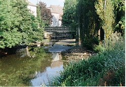
The Bandiat (French pronunciation: [bɑ̃dja]) is a small river in western France, a left tributary of the Tardoire. It flows through the Haute-Vienne, Dordogne and Charente departments. It is 91.4 km (56.8 mi) long. [1]
The Bandiat begins its course just south of the Puy Chauvet (488 m), at roughly 440 m above sea level, near the settlement of Grand Puyconnieux (commune of Dournazac) in the Haute-Vienne department. The river flows first to the southwest and then turns northwest in the Dordogne and, at high water level, empties into the Tardoire ( Charente basin) near Agris in the Charente. Otherwise, the river disappears near Les Vieilles Vaures (commune of Agris) about 5 km before reaching the Tardoire. All the water drains away in several sinkholes in the karst only to reappear near Angoulême as springs of the river Touvre, a tributary of the Charente.
The discharge of the Bandiat was measured near Feuillade as 0.6 m³/s in the summer and 6 m³/s in the winter.
- Abjat-sur-Bandiat
- Nontron
- Javerlhac
- Feuillade
- Marthon
- Saint-Germain-de-Montbron
- Chazelles
- Pranzac
- Rivières
- Agris
-
The same place in summer
-
Drought in August, the mill is on the right
-
The area around Les Vieilles Vaures (commune of Agris) about 5 km from Agris. All water has disappeared in the karst of La Rochefoucauld


