Photos • Location

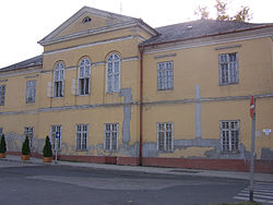
Podmanitzky family palace in Aszód.

Aszód | |
|---|---|
 The House of the Armed Forces Club (formerly the Casino) | |
| Coordinates: 47°39′16″N 19°28′48″E / 47.65451°N 19.47998°E | |
| Country | |
| County | Pest |
| District | Aszód |
| Area | |
| • Total | 16.21 km2 (6.26 sq mi) |
| Population (2015) | |
| • Total | 6,162 |
| • Density | 380/km2 (980/sq mi) |
| Time zone | UTC+1 ( CET) |
| • Summer ( DST) | UTC+2 ( CEST) |
| Postal code | 2170 |
| Area code | (+36) 28 |
| Website |
aszod |

Aszód (Hungarian pronunciation: [ˈɒsoːd]) is a town in Pest county, Hungary.
History
During World War II, Aszód was captured on 7 December 1944 by Soviet troops of the 2nd Ukrainian Front in the course of the Budapest Offensive.
Notable residents
- Sándor Petőfi, Hungarian national poet and liberal revolutionary
- Podmanitzky family, Hungarian noble family
- Aristid von Würtzler, Hungarian harpist, composer, leader of the New York Harp Ensemble
- József Jung, Hungarian architect
- Sándor Sára, Hungarian cinematographer and film director
- Zoltán Huszárik, Hungarian film director, screenwriter, visual artist and actor
- Ignaz Aurelius Fessler, Hungarian ecclesiastic, politician, historian and freemason
- Zoltán Varga, Hungarian footballer, Olympic gold medalist at the 1964 Summer Olympics in Tokyo, Japan
- Duchess Maria Dorothea of Württemberg, Silesian noble, wife of Archduke Joseph, Palatine of Hungary and sister of the great-grandfather of Edward VIII and George VI (father of Queen Elizabeth II), Kings of the United Kingdom
External links
Wikimedia Commons has media related to
Aszód.
- Official website in Hungarian
- Street map (in Hungarian)


