Photos • Location


Anderen | |
|---|---|
Village | |
 Farm in Anderen | |
 The village (dark red) and the statistical district (light green) of Anderen in the municipality of Aa en Hunze. | |
 Anderen Location in the Netherlands  Anderen Anderen (Netherlands) | |
| Coordinates: 53°0′1″N 6°41′8″E / 53.00028°N 6.68556°E | |
| Country | Netherlands |
| Province | Drenthe |
| Municipality | Aa en Hunze |
| Area | |
| • Total | 11.06 km2 (4.27 sq mi) |
| Elevation | 12 m (39 ft) |
| Population (2021)
[1] | |
| • Total | 265 |
| • Density | 24/km2 (62/sq mi) |
| Time zone | UTC+1 ( CET) |
| • Summer ( DST) | UTC+2 ( CEST) |
| Postal code | 9465
[1] |
| Dialing code | 0592 |
Anderen is a village in the Dutch province of Drenthe. It is a part of the municipality of Aa en Hunze, and lies about 8 km east of Assen.
The village was first mentioned in 1217 as Anderne. The etymology is unknown. [3] Anderen is an esdorp without a church which developed in the Early Middle Ages on the Hondsrug. [4]
Anderen was home to 121 people in 1840. [5]
There is no railway station here. The nearest station is Assen station. There are no bus services either, but bus services 10 and 28 stop 1 km south of Anderen on the road cbs.
For further information see Aa en Hunze#Transportation.
-
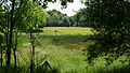 Countryside near Anderen
 -
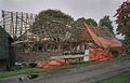 Restoration of a farm


- ^ a b c "Kerncijfers wijken en buurten 2021". Central Bureau of Statistics. Retrieved 10 April 2022.
- ^ "Postcodetool for 9465TJ". Actueel Hoogtebestand Nederland (in Dutch). Het Waterschapshuis. Retrieved 10 April 2022.
- ^ "Anderen - (geografische naam)". Etymologiebank (in Dutch). Retrieved 10 April 2022.
- ^ Ronald Stenvert (2001). Anderen (in Dutch). Zwolle: Waanders. p. 61. ISBN 90 400 9454 3. Retrieved 10 April 2022.
- ^ "Anderen". Plaatsengids (in Dutch). Retrieved 10 April 2022.
Wikimedia Commons has media related to
Anderen.
|
| This Drenthe location article is a stub. You can help Wikipedia by expanding it. |