Photos • Location
| Allaro | |
|---|---|
 | |
 | |
| Location | |
| Country | Italy |
| Physical characteristics | |
| Mouth | Ionian Sea |
• coordinates | 38°20′41″N 16°28′33″E / 38.3447°N 16.4758°E |
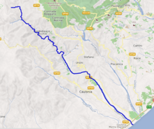
The Allaro ( Calabrian dialect Alaru) is a river in Calabria, Southern Italy. It flows into the Ionian Sea at Marina di Caulonia. It gives its name to the valley through which it runs ( Vallata dello Stilaro Allaro) and is a candidate for the site of the ancient river Sagra. [1]
References
- ^ Richard J.A. Talbert, ed. (2000). Barrington Atlas of the Greek and Roman World: Map-By-Map Directory. Vol. I. Princeton, NJ and Oxford, UK: Princeton University Press. p. 700. ISBN 0691049459.