Photos • Location
Aleksandria | |
|---|---|
Village | |
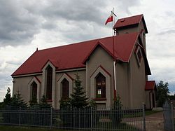
 Church of Saint Maximilian Kolbe | |
| Coordinates: 50°44′N 18°57′E / 50.733°N 18.950°E | |
| Country | |
| Voivodeship | Silesian |
| County | Częstochowa |
| Gmina | Konopiska |
| Elevation | 275 m (902 ft) |
| Population | |
| • Total | 2,131 |
| Time zone | UTC+1 ( CET) |
| • Summer ( DST) | UTC+2 ( CEST) |
| Postal code | 42-274 |
| ISO 3166 code | POL |
| Vehicle registration | SCZ |
| Website | http://konopiska.home.pl/solectwa/aleksandria.pdf |
Aleksandria [alɛkˈsandrja] is a village in the administrative district of Gmina Konopiska, within Częstochowa County, Silesian Voivodeship, in southern Poland. [1] It lies approximately 14 kilometres (9 mi) south-west of Częstochowa and 54 km (34 mi) north of the regional capital Katowice.
The village was founded in honor of Russian Emperor Alexander II. Previously, this area was covered with forest. In Alexandria there is a Church of Maximilian Kolbe built in 1991. There is also the house of the Missionaries of St. Anthony Mary Claret.

