Photos • Location

| Đuống River Thiên Đức River, Canal des Rapides | |
|---|---|
 Đuống River look from Phù Đổng Bridge 2008. | |
| Native name | Sông Đuống ( Vietnamese) |
| Location | |
| Country | Vietnam |
| Tỉnh, thành | Hà Nội, Bắc Ninh |
| Physical characteristics | |
| Source | Cửa Dâu Junction |
| • location | Xuân Canh, Đông Anh District, Hanoi, Vietnam |
| • coordinates | 21°4′51″N 105°50′41″E / 21.08083°N 105.84472°E |
| Mouth | Mỹ Lộc Junction |
• location | Trung Kênh, Lương Tài District, Bắc Ninh Province, Vietnam |
• coordinates | 21°3′21″N 106°18′16″E / 21.05583°N 106.30444°E |
| Length | 68 km (42 mi) |
| Discharge | |
| • location | Thượng Cát |
| • average | 880 m3/s (31,000 cu ft/s) |
| • maximum | 9,000 m3/s (320,000 cu ft/s) |
The Đuống River ( Vietnamese: Sông Đuống), also known as the Thiên Đức River, is a river of Vietnam. It flows for 68 kilometres (42 mi) through Bắc Ninh Province and Hanoi. [1] It was previously known by the French as the Canal des Rapides.
The river features in the poem "On the Other Side of the Đuống River" by Hoàng Cầm. [2]
Gallery
-
 Sunrise on Đuống river
 -
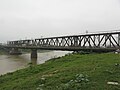 Đuống bridge
 -
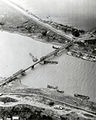 The Duong River Bridge being repaired after the Operation Linebacker in 1972


References
![]() Media related to
Duong River at Wikimedia Commons
Media related to
Duong River at Wikimedia Commons
- ^ Vietnam Administrative Atlas, NXB Bản Đồ, 2004
- ^ Kim Ngoc Bao Ninh A World Transformed: The Politics of Culture in Revolutionary ... 2002 - Page 133 "Hoàng Cầm, well known for his heartbreaking poem "On the Other Side of the Đuống River," which detailed his village's devastation during the anti-French resistance, had become the director of the National Theater Troupe in 1955. He, too ..."
|
| This article about a location in Bắc Ninh province, Vietnam is a stub. You can help Wikipedia by expanding it. |